Atmospheric rivers (ARs) - long, narrow corridors of moisture in the atmosphere - are increasingly recognized as both a source of vital water resources and a driver of extreme flooding events. As climate change intensifies their impacts, space technologies are helping scientists detect, monitor, and predict these “rivers in the sky” to protect lives and infrastructure.
The rising importance of atmospheric rivers
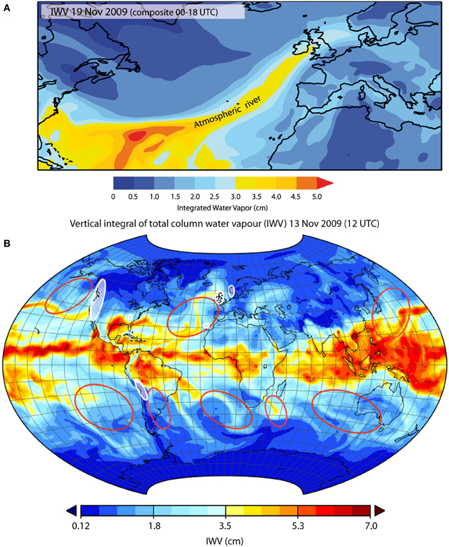
ARs are a global weather phenomenon, and they are exactly what one would picture when hearing the word. They are rivers in the sky. But instead of transporting liquid water, like the ones on the ground, ARs transport a large amount of water vapor from the ocean to the continent. The name stems from their shape, as they are narrow and elongated, stretching over thousands of kilometres. Their defining characteristics include high Integrated Water Vapor (IWV [kilograms per square metres (kg/m2]) content and strong low-level winds, which together result in high Integrated Vapor Transport (IVT [kilograms per metres per second (kg/m/s)]). IVT is a measure of how much water vapor is being carried horizontally through the atmosphere. On average, an AR transports approximately 4.7×10⁸ (±2×10⁸ kilograms per second (kg/s) kilograms of water vapor per second, assuming an IVT of 550 kg/m/s and a typical AR width of 850,000 meters (Ralph et al. 2017). This is about 2.35 times more than the average discharge of the Amazon River, which carries roughly 2×10⁸ kilograms of liquid water per second, based on an average flow of 200,000 cubic metres per second (m3/s) and a water density of 1,000 kilograms per cubic metre (kg/m3).
Studies suggest that over 90 per cent of poleward water vapor transport at mid-latitudes occurs through ARs, despite their occupying only about 10 per cent of the circumference of Earth at any given latitude. In fact, three to five ARs are present in each of the Earth´s hemispheres at any point of time as visualised in figure 1 (Zhu and Newell 1994).
Recent studies suggest that ARs may become 25 per cent wider and longer and transport significantly more moisture due to climate change, even as their overall frequency decreases by 10 per cent (Espinoza et al., 2018; Rhoades et al., 2020; Payne et al., 2020). This intensification will amplify their dual role as both a critical water resource and a driver of extreme weather events.
The dual nature of atmospheric rivers
ARs play a vital role in replenishing water reservoirs, sustaining snowpacks, and irrigating drought-prone regions. However, they can also cause extreme rainfall, floods and landslides, resulting in severe socio-economic impacts.
The winter floods of 1861–1862 in California highlight the immense potential of ARs for destruction. For a period of over 43 days, storms transformed the Central Valley into an inland sea stretching 500 kilometres long and 30 kilometres wide, displacing entire towns and destroying the economy. This “megaflood”, driven by an AR, remains a reminder of the power these phenomena hold (Dettinger and Ingram 2013). As global temperatures rise, the frequency, duration, and intensity of ARs are increasing. The Intergovernmental Panel on Climate Change (IPCC) warns that ARs will bring heavier precipitation and greater flood risks in the future (IPCC, 2023).
By focusing on ARs now, we recognize their critical, and previously underappreciated, role in global water management and the need to adapt to changing climatic conditions.
How space technologies detect and forecast ARs
The detecting and observation of ARs heavily relies on space-based technologies, which provide global coverage and high-resolution data. This is particularly important over remote or oceanic regions where ground-based observations are sparse. Satellite sensors measure key variables such as the Integrated Vapor Transport (IVT) and Integrated Water Vapor (IWV) essential for identifying AR intensity, structure and moisture content. These data not only enable AR detection but also feed into weather models and climate projections, supporting early warning systems (Liu and Hu 2025). A number of examples are provided below.
The Global Navigation Satellite Systems Radio Occultation (GNSS RO) utilizes signals from Global Navigation Satellite Systems (GNSS) that are refracted as they pass through the Earth’s atmosphere. It measures changes in signal phase and amplitude, providing high-resolution vertical profiles of atmospheric temperature, pressure, and humidity. It is effective for detecting the sharp gradients in water vapor content often present in ARs (Rahimi and Foelsche 2024). GNSS RO offers high vertical resolution (100 metre to 1 kilometre) and is unaffected by clouds or precipitation. However, its horizontal resolution is limited (~200 kilometes), and there are gaps in data near the Earth’s surface due to signal loss or interference caused by the dense lower atmosphere. By detecting regions of high humidity and sharp gradients in moisture content, GNSS RO helps identify the vertical structure of ARs. Examples of GNSS RO missions include the Constellation Observing System for Meteorology, Ionosphere and Climate (COSMIC) and its successor COSMIC-2. Additional contributions come from commercial constellations like CubeSats from Spire Global and international missions such as the Meteorological Operational Satellite (MetOp) series from the European Organisation for the Exploitation of Meteorological Satellites (EUMETSAT) and the U.S. Joint Polar Satellite System (JPSS). Together, these platforms provide global, high-vertical-resolution profiles that support the detection and analysis of ARs.
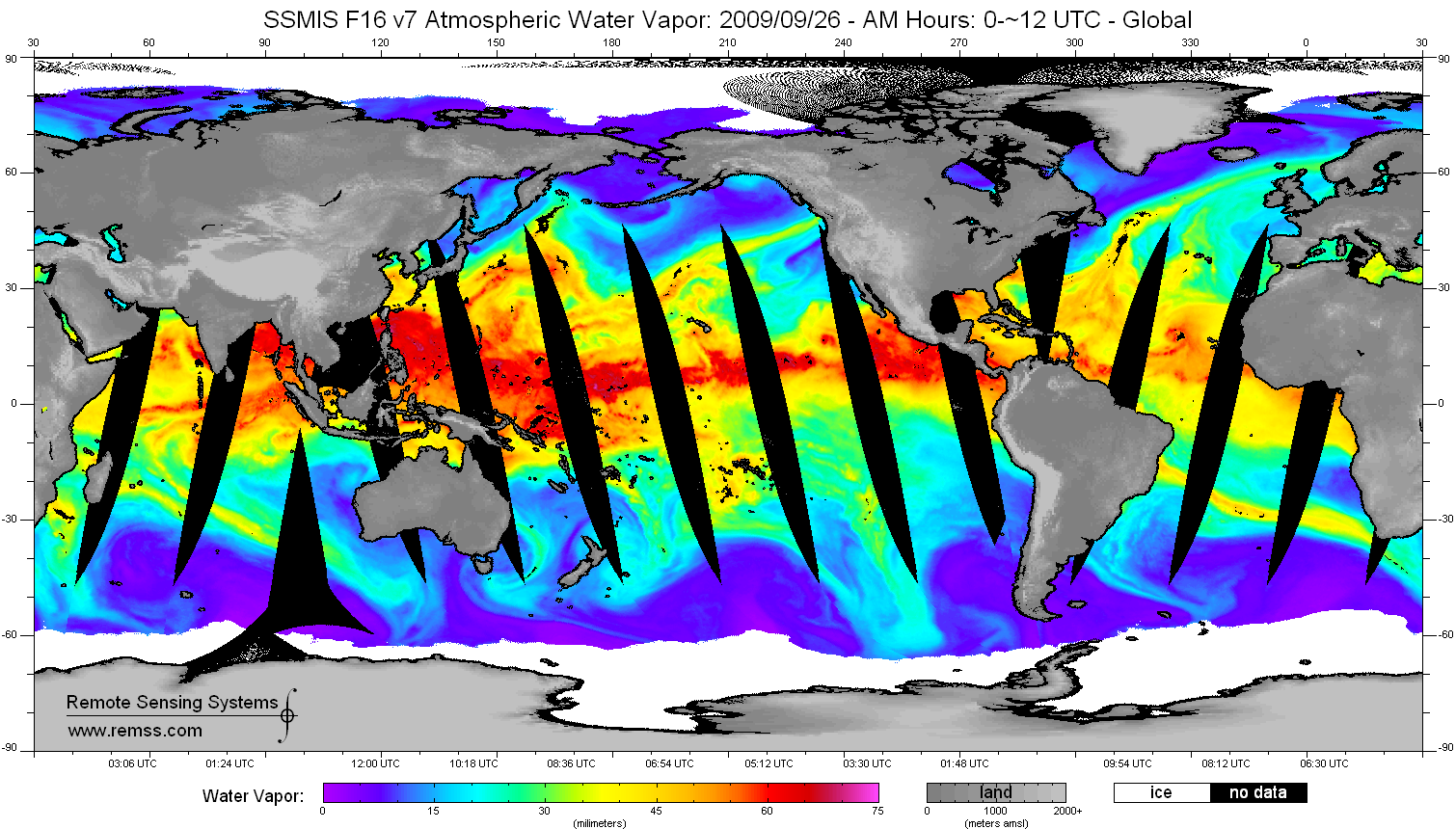
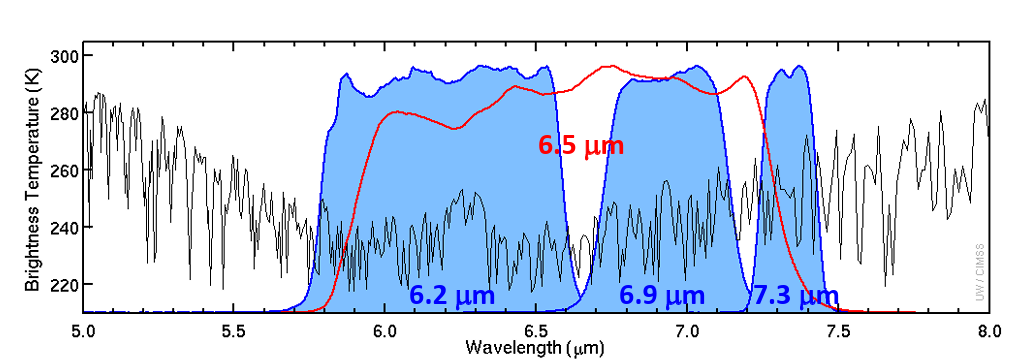
The Special Sensor Microwave Imager/Sounder (SSMI/S) is a passive microwave sensors onboard satellites of the U.S. Defense Meteorological Satellite Program (DMSP). It measures water vapor distribution, sea surface winds, and precipitation. This makes SSMI/S invaluable for tracking ARs over oceans and providing integrated water vapor (IWV) retrievals (Wentz, Hilburn, and Smith 2012, OSCAR 2024). It offers wide horizontal coverage (25-50 kilometres resolution) and is reliable over marine environments, though its accuracy is reduced over land due to surface emissivity variations, visible in figure 2. SSMI/S captures horizontal distributions of water vapor, highlighting the elongated bands characteristic of ARs and is particularly effective over oceans.
Moderate Resolution Imaging Spectroradiometer (MODIS) is an optical sensor onboard NASA´s Aqua and Terra satellites. It captures visual and infrared imagery of atmospheric patterns. This technology helps visualize the movement and extent of ARs, especially their cloud structures and associated precipitation patterns, displayed in figure 3. MODIS captures imagery that shows AR cloud structures and moisture plumes (Yang et al. 2006, NASA 2024a).
With high spatial resolution (~1 kilometre) and global coverage, MODIS captures high-resolution imagery and measures total column water vapor. However, it has limited ability to penetrate dense cloud cover. MODIS detects the moisture-laden bands characteristic of ARs and monitors cloud properties and sea surface temperatures (SST).
Geostationary Operational Environmental Satellites (GOES) are a series of geostationary satellites operated by the U.S. National Oceanic and Atmospheric Administration (NOAA). A geostationary satellite orbits at an altitude of approximately 36,000 kilometres above the equator, moving at the same rotational speed as Earth to remain fixed over a specific location, providing continuous monitoring of that region, illustrated in figure 4.
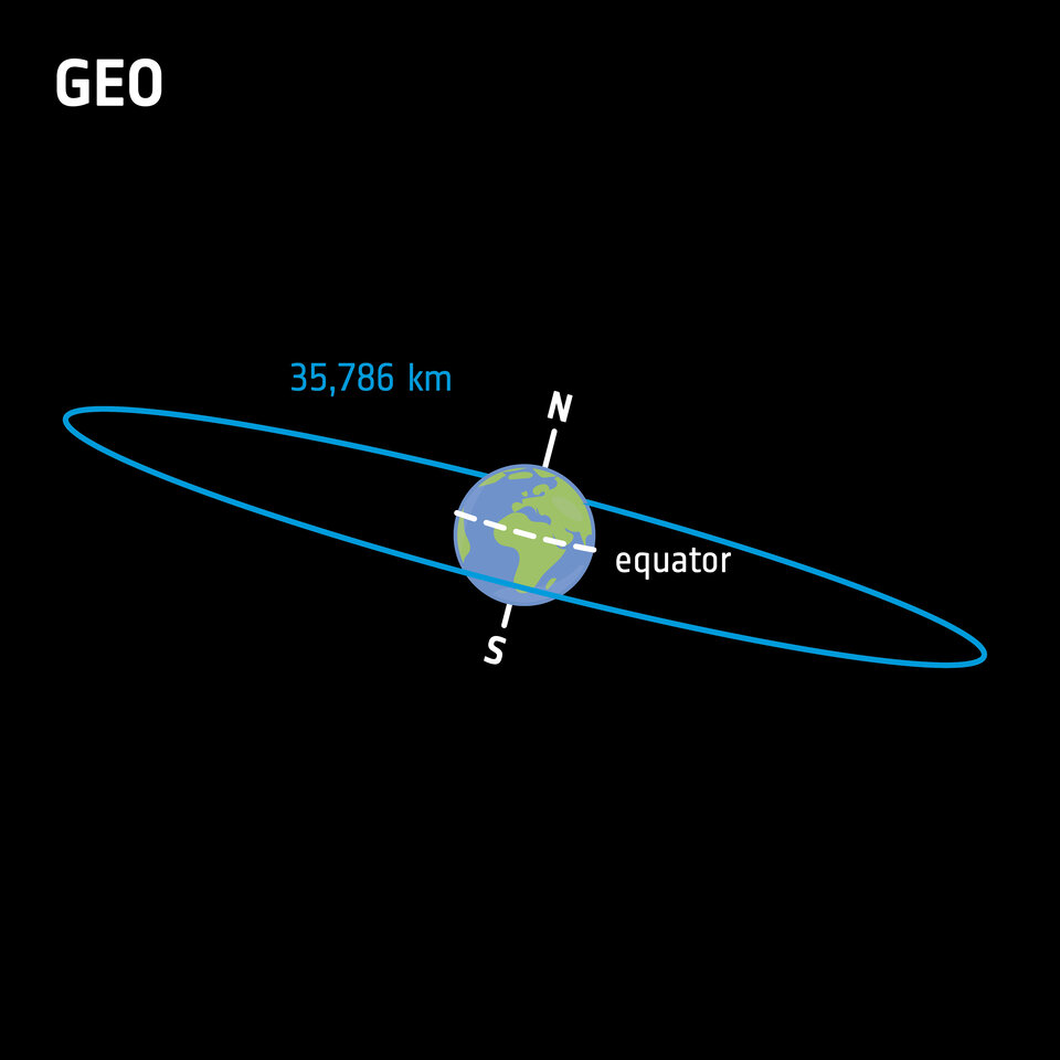
Positioned in fixed orbits 36,000 kilometres above Earth, GOES satellites provide continuous real-time monitoring of atmospheric and surface conditions. The Advanced Baseline Imager (ABI) onboard the current series GOES-R (GOES-16, 17, 18 and 19) captures multispectral imagery, including visible, infrared, and water vapor channels, that are displayed in figure 5 (NASA 2024b).
GOES-R offers near-continuous temporal coverage and is effective for tracking AR movement, though its spatial resolution is lower than that of polar-orbiting sensors like MODIS. Using its water vapor channels and infrared imagery, the satellites detect ARs, providing near-continuous updates on AR cloud structures, moisture content, and movement. This capability makes GOES particularly useful for identifying AR landfall and associated extreme precipitation patterns.
Table 1 below gives an overview of the missions and instruments described above, highlighting their key characteristics and specific contributions to AR research.
| Technology | Mission | In Orbit | Measurements | Spectral resolution | Spatial resolution | Temp. Resolution | Contribution to AR research |
| MODIS | Terra (land monitoring) | 1999 – present (exceeded original 2005 decommissioning target) | - Optical imagery (visible and infrared) - Total column water vapor - Cloud properties - Sea surface temperature (SST) | 36 bands (0.4 – 14.4 µm) | 250m – 1 km (band-dependent) | 1-2 days | Visualizes AR cloud bands and moisture plumes. Tracks SST conditions for AR formation. High-resolution data aids in identifying AR landfall and associated precipitation. |
| MODIS | Aqua (water cycle) | 2002 – 2026 | See Terra | 36 bands (0.4 – 14.4 µm) | 250m – 1 km (band-dependent) | 1-2 days | Complements Terra. |
| GNSS RO | FormoSat-3/ COSMIC-1 | 2006 – 2020 | - High-resolution vertical profiles of water vapor, temperature, and pressure using GPS signals | L1 (1575.42 MHz), L2 (1227.60 MHz) | 300m – 1500m vertical resolution, 300 km – 600 km horizontal resolution | Detects ARs by identifying regions of high humidity and sharp gradients in atmospheric moisture content. Improves numerical weather prediction models for AR forecasting. | |
| GNSS RO (Integrated GPS Occultation Receiver (IGOR)) | 2019 –present (exceeds original 2024 decommissioning target) | See COSMIC-1 | L1 (1575.42 MHz), L2 (1227.60 MHz) | 300m – 1500m vertical resolution, 300 km – 600 km horizontal resolution | Improves coverage in tropical and subtropical regions critical to upstream AR monitoring. | ||
| GNSS RO (GNSS Receiver for Atmospheric Sounding (GRAS)) | MetOp-A | 2006 – 2021 | See COSMIC-1 | L1 (1575.42 MHz), L5 (1176.45 MHz) | 300m– 1500m vertical resolution, 100km – 300 km horizontal resolution | Provides near-global coverage, including polar regions, due to its sun-synchronous polar orbit. This allows it to contribute to AR research worldwide, including high latitudes. | |
| MetOp-B | 2012 – 2026 | See COSMIC-1 | L1 (1575.42 MHz), L5 (1176.45 MHz) | 300m– 1500m vertical resolution, 100km – 300 km horizontal resolution | See MetOp-A | ||
| MetOp-C | 2018 – 2032 | See COSMIC-1 | L1 (1575.42 MHz), L5 (1176.45 MHz) | 300m– 1500m vertical resolution, 100km – 300 km horizontal resolution | See MetOp-A | ||
| SSMI/S | DMSP F16 | 2003 – 2023 | - Microwave measurements of total column water vapor - Sea surface winds - Precipitation data | 24 bands (19.53 GHz-189. 9105 GHz) | varies with the frequency (25 km x 17 km – 70 km x 42 km | Tracks AR moisture plumes over oceans where ground-based observations are limited. Provides data critical for AR analysis in remote areas. | |
| DMSP F17 | 2006 – 2025 | See DMSP F16 | 24 bands (19.53 GHz-189. 9105 GHz) | See DMSP F16 | Global revisit: ~1 per day per satellite | See DMSP F16 | |
| DMSP F18 | 2009 – 2025 | See DMSP F16 | 24 bands (19.53 GHz-189. 9105 GHz) | See DMSP F16 | Global revisit: ~1 per day per satellite | See DMSP F16 | |
| 2014 – 2016 | See DMSP F16 | 24 bands (19.53 GHz-189. 9105 GHz) | See DMSP F16 | Global revisit: ~1 per day per satellite | See DMSP F16 | |
| ABI onboard GOES-R | GOES-16 (former GOES-R)* | 2016 – 2025 | - Continuous real-time imagery - Water vapor channels - Infrared atmospheric patterns | 16 bands (0.47 – 13.3 µm) | 0.5 km– 2 km depending on band in use | 30 sec – 15 min | Monitors AR cloud structures and moisture plumes with high temporal resolution. Tracks ARs dynamically over oceans and during landfall. |
| GOES-17 (former GOES-S)* | 2018 – 2033 | See GOES-16 | 16 bands (0.47 – 13.3 µm) | See GOES-16 | 30 sec – 15 min | See GOES-16 | |
| GOES-18 (former GOES-T)* | 2022– 2037 | See GOES-16 | 16 bands (0.47 – 13.3 µm) | See GOES-16 | 30 sec – 15 min | See GOES-16 | |
| GOES-19 (former GOES-U)* | 2024 – 2039 | See GOES-16 | 16 bands (0.47 – 13.3 µm) | See GOES-16 | 30 sec – 15 min | See GOES-16 |
* “GOES satellites are designated with a letter prior to launch and renamed with a number once they reach geostationary orbit.” (NASA, n.d.)
Space-based observations feed into global models such as the Global Forecast System (GFS) and the European Centre for Medium-Range Weather Forecasts (ECMWF). For example, during recent AR activity on the U.S. West Coast, these models enabled accurate forecasts of heavy precipitation, snow, and high winds (NWS and NOAA 2024). Accurate predictions allow communities to prepare for heavy precipitation, snow, and high winds.
Operational examples of space-based monitoring of ARs/ Building operational capacity for AR forecasting
Space-based observations are increasingly essential for the operational monitoring of ARs with demonstrated benefits for public safety and water resource management. Systems like the Coastal Atmospheric River Monitoring and Early Warning System (CARMEWS) from NOAA integrate satellite data, such as GOES-R and SSMI/S, to provide near real-time assessments of AR characteristics (White et al. 2010; NOAA 2025). Although no evacuation has been publicly attributed solely to an AR forecast to date, these observations routinely support National Weather Service advisories and flood watches in AR-affected regions, such as those in California during the 2021 and 2023 AR events. The Atmospheric River Reconnaissance (AR Recon) program has further enhanced forecast skill by assimilating dropsonde and GNSS RO data into numerical models, with the objective of improving lead times for flood risk management (CW3E 2019;Center for Western Weather and Water Extremes, n.d.). Similarly, the Forecast-Informed Reservoir Operations (FIRO) initiative at Lake Mendocino has successfully used satellite-supported AR forecasts to inform reservoir release strategies, improving water storage without elevating flood risk (Fox 2024; CW3E 2025b). While direct links between AR forecasts and emergency evacuations remain limited, these programs collectively aim to develop operational capacity for issuing timely, location-specific early warnings in response to incoming ARs.
Conclusion: Why satellite technology is critical for tracking atmospheric rivers
ARs are lifelines for water resources but also significant hazards during extreme weather events. They are growing stronger and more frequent due to climate change. By leveraging space technologies like GNSS RO, SSMI/S, MODIS, and GOES, scientists can better detect, monitor, and predict ARs - helping communities adapt and prepare. Space-based data contributes not only to water resource management but also to early warning systems, saving lives and livelihoods globally. Understanding ARs today is a call to action for adapting to a rapidly changing climate.

Center for Western Weather and Water Extremes. 2019. “Atmospheric River Research, Mitigation, and Climate Forecasting Program.” April. https://cw3e.ucsd.edu/wp-content/uploads/CW3E_ARProgramPhase1_FinalRepo….
Center for Western Weather and Water Extremes. n.d. Atmospheric River Reconnaissance.
Center for Western Weather and Water Extremes.. 2025. “Forecast Informed Reservoir Operations.” Accessed August 6. https://cw3e.ucsd.edu/firo_lake_mendocino_fva/.
Dettinger, Michael D, and B Lynn Ingram. 2013. “The Coming Megafloods.” Scientific American.
Espinoza, Vicky, Duane E Waliser, Bin Guan, David A Lavers, and F Martin Ralph. 2018. “Global Analysis of Climate Change Projection Effects on Atmospheric Rivers.” Geophysical Research Letters 45 (9): 4299–4308. doi:10.1029/2017GL076968.
European Space Agency (ESA). 2020. “Types of Orbits.” March 30.
Fox, Alex. 2024. “Taking Flight: UC San Diego Shaping Future of Atmospheric River Forecasting.” Scripps Institution of Oceanography. https://scripps.ucsd.edu/news/taking-flight-uc-san-diego-shaping-future….
Francis, Diana, Ricardo Fonseca, Narendra Nelli, Deniz Bozkurt, Ghislain Picard, and Bin Guan. 2022. “Atmospheric Rivers Drive Exceptional Saharan Dust Transport towards Europe.” Atmospheric Research 266: 105959. doi: doi.org/10.1016/j.atmosres.2021.105959.
Gimeno, L., Nieto, R., Vázquez, M., & Lavers, D. (2014). Atmospheric rivers: a mini-review. Frontiers in Earth Science, 2. https://doi.org/10.3389/feart.2014.00002
Intergovernmental Panel on Climate Change (IPCC), ed. 2023. “Water Cycle Changes.” In Climate Change 2021 – The Physical Science Basis: Working Group I Contribution to the Sixth Assessment Report of the Intergovernmental Panel on Climate Change, 1055–1210. Cambridge: Cambridge University Press. doi: 10.1017/9781009157896.010.
Liu, Tianying, and Shineng Hu. 2025. “An Algorithm to Develop a Satellite-Based Atmospheric River Database.” Geophysical Research Letters 52 (5): e2024GL111316. doi:10.1029/2024GL111316.
NASA. 2024a. “MODIS Moderate Resolution Imaging Spectroradiometer.”
NASA. 2024b. “GOES Satellite Network.” November.
NASA. n.d. “Geostationary Operational Environmental Satellites—R Series A Collaborative NOAA & NASA Program.” National Oceanic and Atmospheric Administration.
NASA Earth Observatory. 2023. “Atmospheric River Lashes California,” January.
NOAA. 2025. “NOAA’s Atmospheric River Research: Serving up Data Rain or Shine - NOAA Research.” Accessed August 6. https://research.noaa.gov/noaas-atmospheric-river-research-serving-up-d….
NWS, and NOAA. 2024. “U.S. Week-2 Hazards Outlook - Made December 17, 2024.” National Weather Service (NWS) Climate Predicion Center. December 17.
Observing Systems Capability Analysis and Review Tool (OSCAR). 2024. “Instrument SSMIS.”
Payne, Ashley E, Marie-Estelle Demory, L Ruby Leung, Alexandre M Ramos, Christine A Shields, Jonathan J Rutz, Nicholas Siler, Gabriele Villarini, Alex Hall, and F Martin Ralph. 2020. “Responses and Impacts of Atmospheric Rivers to Climate Change.” Nature Reviews Earth & Environment 1 (3): 143–57. doi:10.1038/s43017-020-0030-5.
Rahimi, B, and U Foelsche. 2024. “Observing Atmospheric Rivers Using GNSS Radio Occultation Data.” Atmospheric Measurement Techniques Discussions 2024: 1–40. doi:10.5194/amt-2024-81.
Ralph, F. Martin, S. F. Iacobellis, P. J. Neiman, J. M. Cordeira, J. R. Spackman, D. E. Waliser, G. A. Wick, A. B. White, and C. Fairall. 2017. “Dropsonde Observations of Total Integrated Water Vapor Transport within North Pacific Atmospheric Rivers.” Journal of Hydrometeorology 18 (9). American Meteorological Society: 2577–96. doi:10.1175/JHM-D-17-0036.1.
Rhoades, Alan M, Andrew D Jones, Abhishekh Srivastava, Huanping Huang, Travis A O’Brien, Christina M Patricola, Paul A Ullrich, Michael Wehner, and Yang Zhou. 2020. “The Shifting Scales of Western U.S. Landfalling Atmospheric Rivers Under Climate Change.” Geophysical Research Letters 47 (17): e2020GL089096. doi: 10.1029/2020GL089096.
Wentz, F.J., K.A. Hilburn, and D.K. Smith. 2012. “SSMI / SSMIS.” Santa Rosa, CA: Remote Sensing Systems.
White, Allen B., F. Martin Ralph, Paul J. Neiman, Daniel J. Gottas, and Seth I. Gutman. 2010. “The NOAA Coastal Atmospheric River Observatory.”
Yang, F, M A White, A R Michaelis, K Ichii, H Hashimoto, P Votava, A-X. Zhu, and R R Nemani. 2006. “Prediction of Continental-Scale Evapotranspiration by Combining MODIS and AmeriFlux Data Through Support Vector Machine.” IEEE Transactions on Geoscience and Remote Sensing 44 (11): 3452–61. doi:10.1109/TGRS.2006.876297.
Zhu, Yong, and Reginald E Newell. 1994. “Atmospheric Rivers and Bombs.” Geophysical Research Letters 21 (18): 1999–2002. doi: 10.1029/94GL01710.