Challenge-ID
80
Description

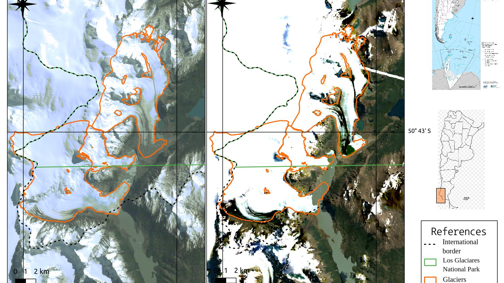
Los Glaciares National Park is located southwest Argentina. It covers more than 700000 ha. and has many large glaciers which are responsible for feeding two huge lakes (Viedma and Argentino lake) with melting water. This meltwater crosses arid Patagonia and provides drinking water to the entire basin.

There is poor information about how much ice and snow melts every year. Elevation data for mass balance calculations is provided by remote sensing technologies, however free access is scarce. Changes in elevation can only be measured between four free digital elevation models (DEM) of mid-resolution, and each one corresponds to a specific year. That means only three mass balance calculations can be done.

The area is remote and vast, therefore we rely on remote sensing information.

Has this problem been acknowledged in the past?

Partly, however, commercial elevation data or in situ data has been used.

Can this challenge be solved using space technologies and data?

Yes, using mid- or high-resolution DEM of every year.

Expected timeframe to develop a solution

This is a continuous work. Still, mass balance calculations are almost immediate when having the updated information.

Potential consequences if no action happens

Lack of information about the solid water reserves in the basin, unawareness of the regulatory capacity of these bodies on the river flow in extreme weather conditions.

Problem Definition
There is no free elevation data over the glaciers of every year. There are only four free DEM (SRTM, ASTER, ALOS and TanDEM missions) and lidar points from ICESAT missions that do not cover the whole area. There is a need for elevation data for shorter periods, ideally at the end of the summer season (March-April) and in an annual basis.

Changes in elevation measured for shorter periods of time leads to better estimates of trends. This data can then be related to flow rates measured in the basin and meteorological variables.
Success criteria
Having one DEM per year, acquired at the end of the summer season (March-April).

Relevant data sources/publications

GRAS. “Grupo De Radares de Apertura Sintética.” GRAS - UTN FRH (2025).  https://gras.com.ar/.

Ortone Lois, A. S., & Pilato, G. L. “A hidden secret that becomes water: Monitoring Patagonian Glacier Retreat.” Space4Water Portal (2020). https://www.space4water.org/news/hidden-secret-becomes-water-monitoring-patagonian-glacier-retreat.

Pilato, G. L., Ortone Lois, A. S., Barrios, A., Saavedra, S., & Macote Yparraguirre, E. L. “Space technology applied to patagonian glaciers and their behavior as environmental indicators.” Revista Cartográfica 104 (2022): 133–163. https://doi.org/10.35424/RCARTO.I104.1049.

Torres, H., Brenning, A., & García, J.-L. “Balance de masa del glaciar cubierto del Pirámide (Chile Central, 33°S) entre 1965 y 2000 aplicando métodos geodésicos.” Revista de Geografía Espacios 3, no.5 (2017): 11–25. https://doi.org/10.25074/07197209.5.345.

Universidad Tecnológica Nacional Regional Haedo. “saroptico (Synthetic Aperture Radar research group).” GitHub (2025). https://github.com/saroptico.

Regular elevation data for mass balance estimations in Patagonian glaciers

Regular elevation data for mass balance estimations in Patagonian glaciers

Keywords
Climate Zone
Habitat
Region/Country
Related SDGs
Relevant solutions