Lake Ol’ Bolossat, the only lake in Central Kenya and the 7th Ramsar site in Kenya, is facing a severe ecological crisis as it steadily disappears due to environmental degradation, unsustainable water use, and climate change. This has led to biodiversity loss, economic decline, and disruption of water supply to the Ewaso Nyiro River.
Has this problem been acknowledged in the past?
- Government Recognition
- 2019: Declaration as a Protected Area: The Kenyan government officially designated Lake Ol' Bolossat as a protected area under the Wildlife Conservation and Management Act, citing its ecological importance as a Ramsar site and IBA (Important Bird Area).
- 2020: County Government Interventions: Nyandarua County launched a "Save Ol’ Bolossat" campaign, pledging to: demarcate wetland boundaries, evict illegal settlers and promote conservation agriculture.
- Kenya Water Towers Agency (KWTA): Listed the lake’s catchment (Aberdare Range) as a critical water tower, but prioritization lags behind larger ecosystems like Mau Forest.
- NGO & Research Reports
- Kenya Wetlands Forum (KWF) & BirdLife International: Published studies (e.g., 2022 Synthess Report) highlighting: 75% reduction in lake size since 1980s and Loss of 300+ bird species habitats, including endangered Grey Crowned Cranes.
- Ramsar Convention: Listed the lake as a Wetland of International Importance (2005) but flagged Kenya for "inadequate protection measures" in 2020 reports.
- Documentaries
- NTV Kenya’s "Vanishing Waters" (2023) exposed illegal farming and siltation.
- Protests
- Local fishermen and conservationists held demonstrations in 2022 demanding action against polluters.
Can this challenge be solved using space technologies and data?
Yes, space-based technologies offer powerful tools for monitoring, analyzing, and mitigating the lake’s degradation. In particular, Earth observation satellites can provide continuous, high-resolution data that enable monitoring of lake surface area, water quality, and surrounding land use. For instance, radar imaging from ESA’s Sentinel-1 and optical data from Sentinel-2 or NASA’s Landsat missions are commonly used to track changes in water extent, detect vegetation shifts, and assess soil moisture—all critical factors in understanding lake degradation. Additionally, satellite altimetry and gravimetric missions (e.g., GRACE) help estimate changes in water storage over time. These technologies collectively enable proactive management by providing timely, accurate data to inform conservation and sustainable water management practices.
Expected timeframe to develop a solution
2 - 3 years
Potential consequences if no action happens
- Complete loss of Lake Ol’ Bolossat, leading to irreversible biodiversity collapse.
- Displacement of communities reliant on the lake’s ecosystem services.
- Increased human-wildlife conflict as animals search for alternative water sources.
- Reduced water availability for downstream users, impacting agriculture and pastoralism.
- Economic downturn due to lost tourism revenue and disrupted local markets.
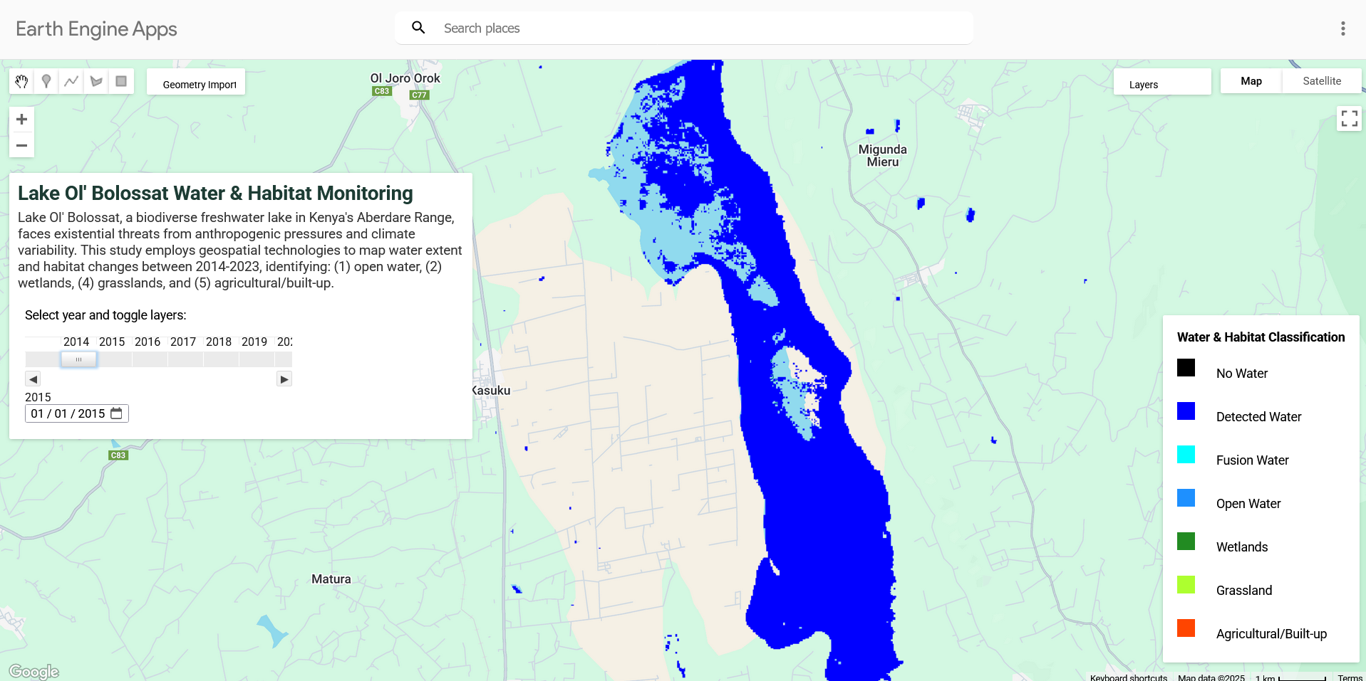
Map of Water and Habitat Classification of Lake Ol' Bolossat, Kenya in 2014-2023
However, the lake is rapidly shrinking due to deforestation, encroachment, excessive water abstraction for irrigation, and climate variability. Studies have indicated a drastic reduction in lake size over the past two decades, with satellite imagery showing seasonal fluctuations that exacerbate its decline. Scientific research from the Kenya Wetlands Forum and BirdLife International highlights that siltation, pollution, and altered hydrology are primary drivers of degradation. Furthermore, unsustainable agricultural practices in the lake’s catchment area have intensified erosion and sedimentation, reducing water quality and aquatic biodiversity. The absence of effective regulatory enforcement has allowed human activities to continue unchecked, worsening the crisis.
Measurable Indicators of Success