

This country case provides an in-depth analysis of Brazil's efforts in utilizing space technology for water resource management, disaster prevention, and supporting sustainable development. It highlights key projects, such as the CBERS satellite program, the use of remote sensing for monitoring water bodies, and partnerships with agencies like NASA and the European Space Agency. Brazil's space policy is aligned with its national development goals, focusing on technological autonomy, environmental monitoring, and meeting the Sustainable Development Goals (SDGs), particularly SDG 6 related to water and sanitation. The document also covers challenges in infrastructure development, climate change impacts, and the need for public policy integration to enhance space technology's contribution to water resource management.
Contents
- Meteorology, Climate Change, and Ecosystems
- Main Water Bodies, Water Resources, and Aquatic Ecosystems
- Water Sector Information
- Integrated Water Resource and River Basin Management
- WASH Policy (Water, Sanitation, and Hygiene)
- Transboundary Agreements on Water
- Cooperation and other relevant aspects
- Space policy, Economy, and Space Law
- SDG Reporting
- Space and water related actors, projects, missions, initiatives, community portals, software, tools models and APIs in Brazil
Meteorology, Climate Change, and Ecosystems
Brazil's vast and diverse landscape is home to various ecosystems that are deeply influenced by meteorological conditions. Climate change plays a significant role in shaping these ecosystems, leading to more frequent extreme weather events such as droughts, floods, and shifts in temperature and rainfall patterns. Brazil's ecosystems, ranging from the Amazon rainforest to the semi-arid regions of the Northeast, are sensitive to changes in temperature and precipitation, which in turn affect biodiversity, water resources, and agricultural productivity.
Rising temperatures due to global climate change have exacerbated drought conditions in some regions while increasing the intensity of rainfall in others. These alterations have affected the natural cycles within ecosystems, leading to disruptions in plant and animal life, and stressing the overall ecological balance.
Climate Zones (Köppen-Geiger)
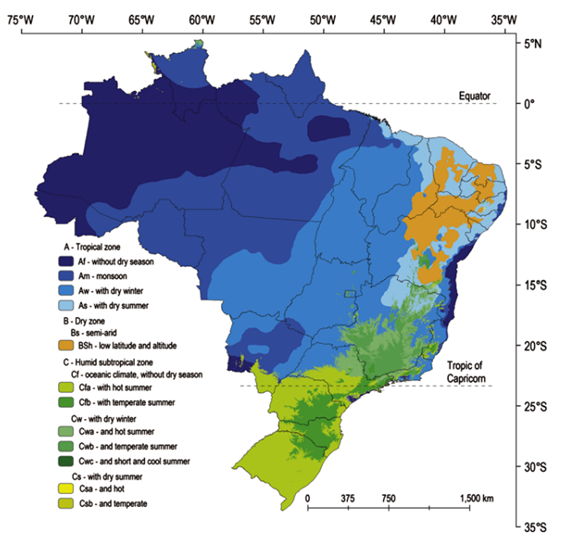
Brazil's climate can be classified into several Köppen-Geiger climate zones due to its extensive size and geographic diversity. The country is located predominantly within tropical and subtropical latitudes, resulting in a wide range of temperature and precipitation patterns:
1. Tropical Rainforest Climate (Af) – Predominantly found in the Amazon Basin, this region experiences hot temperatures and high rainfall throughout the year, with no distinct dry season.
2. Tropical Savanna Climate (Aw) – Found in Central Brazil, including parts of the Cerrado region, this climate features a distinct wet and dry season, with high temperatures year-round.
3. Humid Subtropical Climate (Cfa) – Present in southern Brazil, including parts of Paraná and Rio Grande do Sul, where the climate is characterized by mild winters and hot summers, with no dry season.
4. Semi-arid Climate (BSh) – Found in the Northeast (Sertão), this region has high temperatures and very low rainfall, contributing to recurring droughts.
5. Temperate Oceanic Climate (Cfb) – Found in the highland regions of the South, such as parts of Santa Catarina, this climate is characterized by cooler temperatures and consistent rainfall.
Brazil’s vastness leads to significant regional variation in temperature and precipitation patterns, making it one of the most climatically diverse countries in the world.
Rainy Season
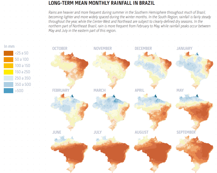
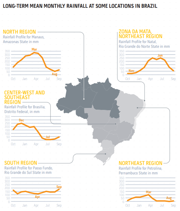
The rainy season in Brazil varies by region but is generally influenced by tropical and equatorial climate dynamics. In most of the country, the rainy season occurs during the southern summer months from December to March, when the Intertropical Convergence Zone (ITCZ) brings heavy rainfall. This period is crucial for agricultural activities, replenishing water resources, and maintaining the health of ecosystems, especially in regions like the Amazon and Pantanal.
In contrast, the Northeast's semi-arid region experiences less predictable rainfall patterns, with some areas receiving limited rainfall even during the wet season. In the Cerrado region, the rainy season is essential for supporting biodiversity and water flow in rivers that feed into major basins like the Amazon and Paraná.
Dry Season
The dry season in Brazil typically occurs between May and September, particularly in regions with a tropical savanna climate (Cerrado) and in the semi-arid northeast.
This period is characterized by:
- Low humidity levels
- Increased temperatures due to reduced cloud cover
- Decreased river flows and groundwater recharge
- High risk of wildfires, especially in the Amazon and Cerrado, exacerbated by deforestation and land use changes
- Agricultural stress, as crops rely heavily on irrigation due to the lack of rainfall.
Meteorological Observations and Water-related Disasters
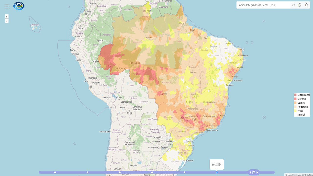
Brazil faces a variety of water-related disasters driven by meteorological extremes, such as droughts, floods, and landslides. Meteorological observations are crucial for monitoring these events and mitigating their impacts. The National Hydrometeorological Network (RHN) is vital in this regard, comprising a network of 23,000 observation stations that monitor rainfall, river levels, and water quality.
Water-related disasters such as droughts in the Northeast (Sertão) and floods in southern and southeastern regions (São Paulo, Minas Gerais) have become more frequent and severe due to climate change.
Droughts have resulted in water shortages and a decline in agricultural productivity, while floods have led to significant economic damage and loss of life. Efforts to mitigate these disasters include:
- The Monitor de Secas: A tool that tracks drought conditions and informs emergency responses.
- Operation Carro-Pipa: Provides emergency water supplies to regions affected by prolonged droughts.
- Hydrological crisis management plans to prevent the depletion of reservoirs used for water supply and energy production.
Main Water Bodies, Water Resources, and Aquatic Ecosystems
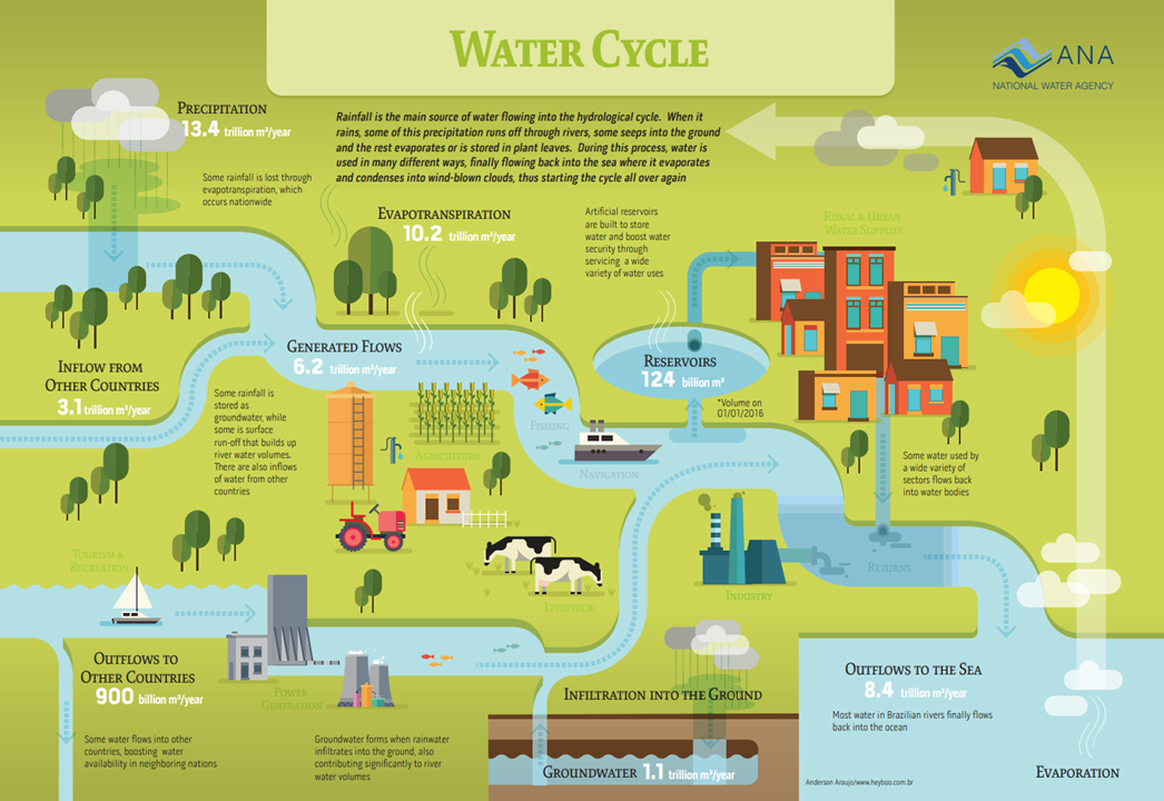
Groundwater and Surface Water (Resources)
Significant Rivers
Brazil has several significant rivers, including:
- Amazon River, the largest river by volume in the world, running across the Northern region of Brazil.
- São Francisco River, which flows from the Southeast through the Northeast and is essential for irrigation and water supply in semi-arid regions.
- Paraná River, one of the longest rivers in South America, crucial for hydropower and navigation.
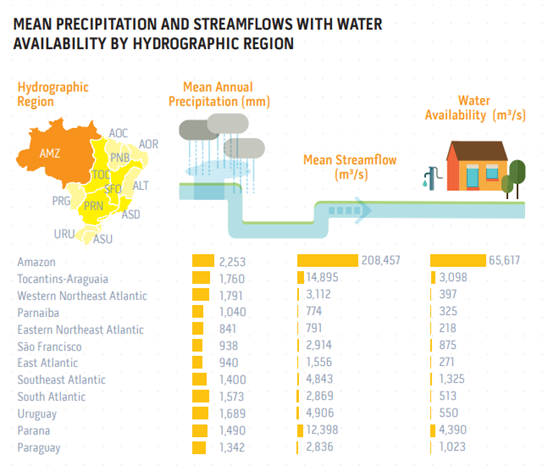
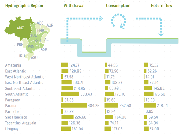
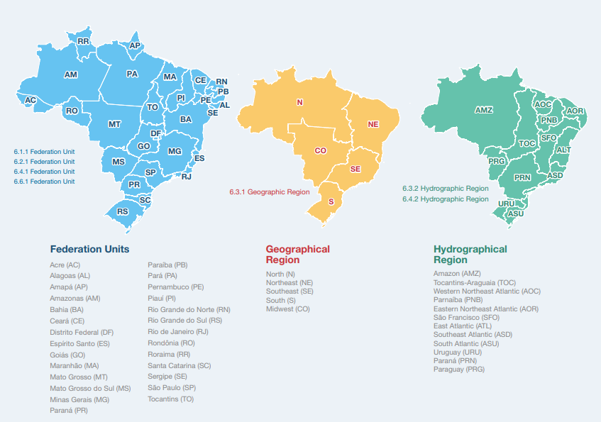
Brazil is divided into 12 major drainage basins, comprising watersheds with rivers and tributaries: Brazil's water management is structured around 12 major hydrographic regions, which encompass numerous rivers, tributaries, and watersheds. These basins ensure water distribution across different regions of the country, despite the unequal distribution of water resources.
Water supply: Brazil is rich in water resources, with 12% of the world’s available freshwater. However, the supply is uneven, with the Amazon Basin holding 81% of the country's water, while the Northeast faces water scarcity due to less rainfall.
Water Sources
The most essential water sources in Brazil include:
- Surface water: Rivers such as the Amazon, Paraná, and São Francisco.
- Groundwater: The Guarani Aquifer, one of the largest aquifers globally, is essential for providing water for agriculture, industry, and domestic use.
Surface water/lakes: Brazil’s surface water is primarily sourced from its extensive river systems, reservoirs, and lakes, both natural and man-made. These bodies of water are crucial for hydropower, agriculture, and drinking water supply.
Groundwater: Groundwater provides 20% of the water used for agriculture, industry, and domestic needs, particularly in regions that face surface water shortages.
Aquatic Ecosystems
Wetlands
Brazil contains vast wetland ecosystems, the largest of which is the Pantanal, known as the world’s largest tropical wetland. These ecosystems are vital for maintaining biodiversity, supporting flood control, and preserving water quality.
Others
In addition to wetlands, Brazil has coastal ecosystems like mangroves, freshwater ecosystems in rivers and lakes, and the diverse aquatic ecosystems within the Amazon Rainforest. These ecosystems are critical for supporting numerous species, regulating the hydrological cycle, and providing ecosystem services such as water purification.
Principal water use
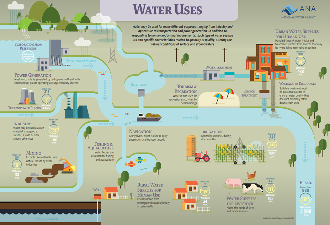
Water use in Brazil is dominated by agriculture, followed by industry and hydropower. Water is also crucial for domestic use, with significant variations in availability between regions. Water resource management faces challenges due to the unequal geographic distribution of resources.
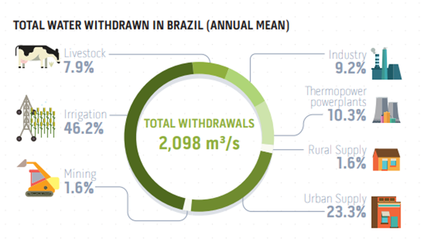
Agriculture water use
- Agriculture is the largest consumer of water in Brazil, utilizing around 72% of the country’s total water supply.
- Approximately 80% of cultivated land relies on surface water irrigation: Most of the agricultural land that is irrigated relies on surface water sources such as rivers and reservoirs.
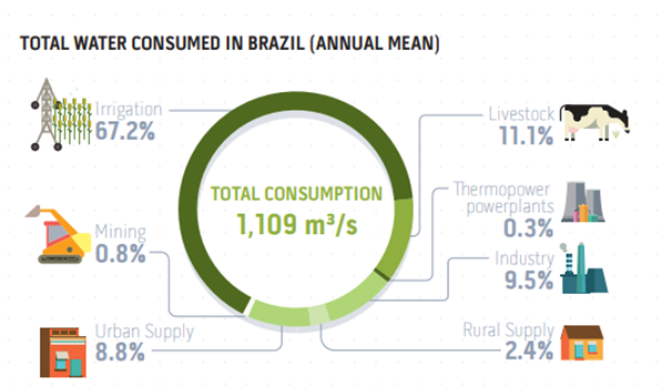
Hydropower generation
Hydropower energy production: Hydropower is the most significant source of energy in Brazil, generating around 60% of the country's total electricity. The country’s large river systems make it ideal for hydropower production.
Dams in the country: Brazil has over 1,400 hydroelectric dams, including the Itaipu Dam on the ParanáRiver, which is one of the largest hydroelectric plants in the world.
Ecosystem related to dams: Dams have a considerable impact on ecosystems, particularly on river flow, sediment transport, and fish migration. Brazil has implemented environmental regulations to minimize these impacts, although there are ongoing concerns about the sustainability of large dam projects.
Other Large Water Uses (Industry, Mining, etc.)
Industry and mining: Industries such as steel production and mining are significant water consumers, using around 22% of the total water supply. Mining activities, particularly in states like Minas Gerais, demand large amounts of water for mineral processing.
Groundwater
Groundwater: Groundwater is essential, particularly in regions like the semi-arid Northeast, where surface water is scarce. The Guarani Aquifer is a major source of groundwater, providing critical support for agriculture and urban water supply.
Land Area
Brazil is the largest country in South America, covering an area of 8.5 million km².(5th in the world).
Population
Brazil has the 7th largest population: 216 million people.
Population density: Brazil has an overall population density of about 25 people per km², though this varies significantly by region. Population density in Brazil is highly uneven, with the majority of people concentrated in the Southeast (São Paulo, Rio de Janeiro), where urban centers have densities over 160 people per km². The South and Northeast have moderate densities (50 to 100 people per km²), especially along the coast, while the Central-West and North regions, including the Amazon rainforest, are sparsely populated with densities often below 10 people per km².
Population concentration: Around 87% of Brazil's population lives in urban areas, contributing to the concentration of people in major cities like São Paulo, Rio de Janeiro, and Brasília.
Urban centres and coastal regions: A significant portion of the Brazilian population, approximately 111 million people, representing 54.8% of the citizens, lives in a narrow coastal strip just 150 km wide. This population concentration is along Brazil’s coast, covering major urban centers such as São Paulo, Rio de Janeiro, Salvador, and Recife. These regions are densely populated due to developed infrastructure, economic opportunities, and proximity to industrialized and port areas.
Water Sector Information
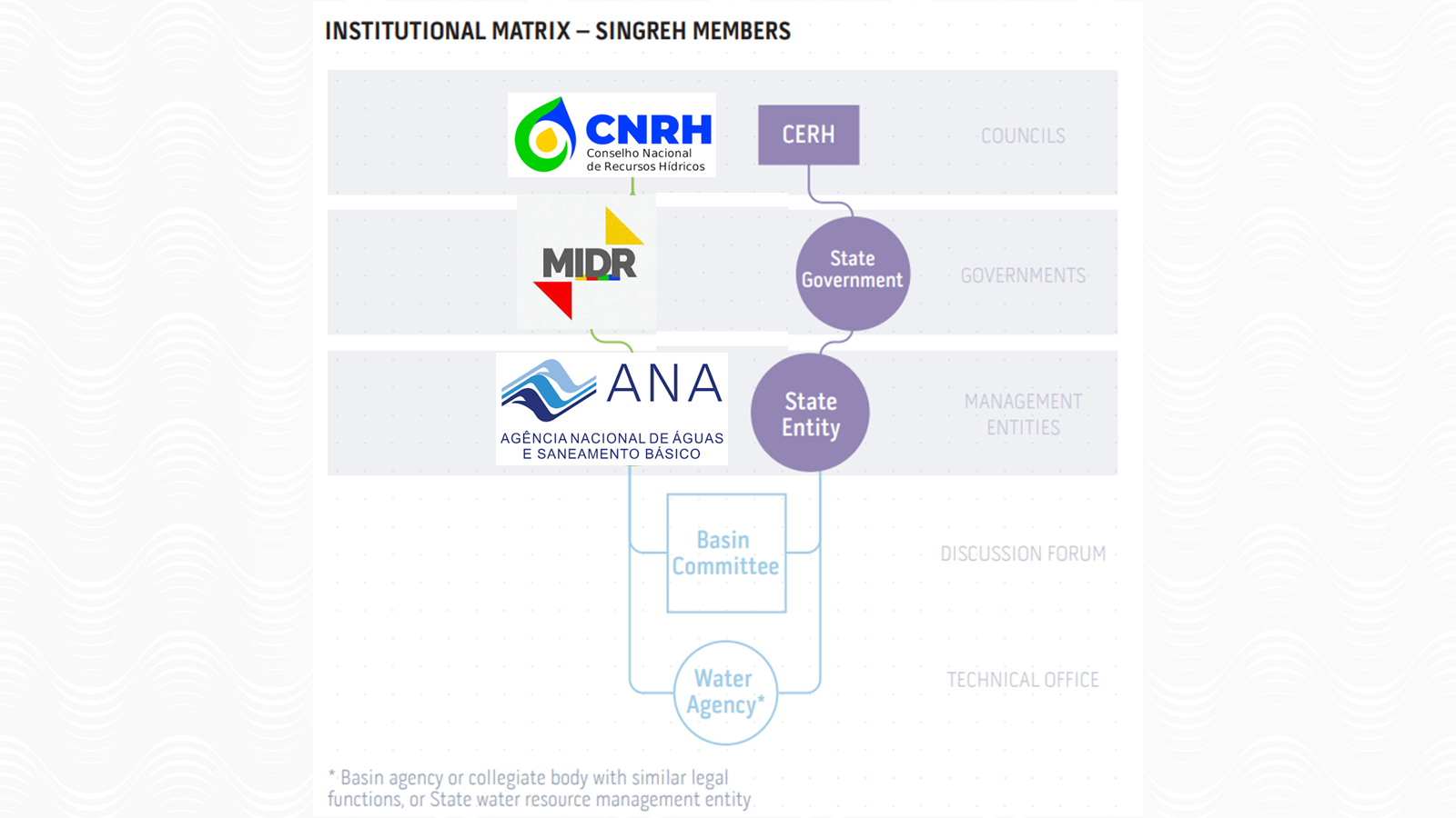
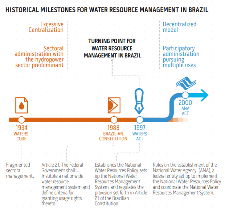
The water sector in Brazil is managed through a collaborative framework that includes government institutions, academia, private sectors, civil society, and international organizations. The Sistema Nacional de Gerenciamento de Recursos Hídricos (SINGREH) coordinates water management across multiple sectors and ensures sustainable use of water resources. This system integrates the Política Nacional de Recursos Hídricos (PNRH), established by Law No. 9.433/1997, which sets out the principles and guidelines for water resource management in Brazil.
Water management is critical due to Brazil's vast geographic differences, from the water-abundant Amazon Basin to the semi-arid regions of the Northeast, where droughts are common. The system relies heavily on collaborative efforts between local and federal governments, basin committees, and various stakeholders, including indigenous communities and private industries.
GOVERNMENT
1. Ministério da Integração e do Desenvolvimento Regional (MIDR)
Roles and Responsibilities: The MIDR or Ministry of Integration and Regional Development manages water resources, develops infrastructure projects, promotes regional development, and coordinates disaster response to ensure sustainable urban growth and water security. MIDR plays a crucial role in regional development, focusing on water resource management in regions prone to water scarcity, like the Northeast. It is responsible for overseeing and implementing large infrastructure projects such as water transposition systems, irrigation networks, and disaster response efforts during periods of droughts and floods.
Water-Related Challenges: Water resource allocation in water-scarce regions, especially during droughts, and balancing the needs of agriculture, human consumption, and environmental sustainability.
1.1. Agência Nacional de Águas e Saneamento Básico (ANA)
Roles and Responsibilities: ANA or National Water and Sanitation Agency is the key national agency responsible for regulating and managing Brazil's water resources. It implements the Política Nacional de Recursos Hídricos (PNRH), which establishes guidelines for the sustainable use of water. ANA oversees water allocation permits (outorgas), monitors water quality, manages the use of rivers and reservoirs, and promotes integrated water management at both national and regional levels, also in conjunction with State Water Resources Management Bodies.
Water-Related Challenges: Managing water resources in regions affected by frequent droughts, improving water use efficiency, and ensuring equitable access to water across the country.
1.2. Conselho Nacional de Recursos Hídricos (CNRH)
Roles and Responsibilities: CNRH is Brazil's National Water Resources Council, which operates under the Ministry of Regional Development (MDIR). NRH develops national water policies, coordinates multi-level governance, ensures stakeholder participation, and mediates conflicts over water resource management.
Water-Related Challenges: CNRH addresses water challenges by promoting sustainable water use, managing scarcity, resolving conflicts, and enhancing water security in the face of climate change.
2. Ministério do Meio Ambiente e Mudança do Clima (MMA)
Roles and Responsibilities: The Ministry of Environment and Climate Change is responsible for creating and implementing policies to preserve the environment and ensure sustainable management of natural resources, including water. The MMA plays a key role in integrating climate change considerations into water management practices, working on projects to protect ecosystems that depend on healthy water systems.
Water-Related Challenges: Addressing the impacts of climate change on water availability, particularly in vulnerable ecosystems, and integrating conservation with economic activities that rely on water.
2.1. Instituto Brasileiro do Meio Ambiente e dos Recursos Naturais Renováveis (IBAMA)
Roles and Responsibilities: IBAMA is Brazil's environmental regulatory body, responsible for overseeing environmental licensing and ensuring compliance with environmental laws. It regulates activities that impact water resources, such as hydropower development, mining, and industrial processes. IBAMA works to balance economic development with environmental sustainability.
Water-Related Challenges: Ensuring that large infrastructure projects like dams and industrial plants are developed in ways that minimize their impact on water ecosystems and local communities.
3. Ministério de Minas e Energia (MME)
Roles and Responsibilities: The Ministry of Mines and Energy oversees energy production in Brazil, including the management of hydropower, which relies heavily on water resources. The MME works closely with ANA and IBAMA to ensure that the country's energy needs are balanced with sustainable water management practices.
Water-Related Challenges: Managing the impact of hydropower dams on river ecosystems, fish migration, and sediment flows, while maintaining energy production.
3.1. Serviço Geológico do Brasil (SGB)
Roles and Responsibilities: SGB (CPRM) is Brazil’s geological survey and research institution. Together with ANA, It plays a significant role in mapping and monitoring Brazil’s groundwater resources, conducting hydrogeological studies, and assessing the risks posed by geological hazards to water resources.
Water-Related Challenges: Over-extraction of groundwater, contamination risks, and ensuring that groundwater resources are used sustainably to meet agricultural, industrial, and urban water needs.
ACADEMIA
Universities and Research Institutes
Roles and Responsibilities: Universities and academic institutions contribute to water management through research on water sustainability, hydrological modeling, and environmental impacts.
Water-Related Challenges: They collaborate with governmental agencies and international organizations on water projects and policy development.
INTERNATIONAL ORGANIZATIONS (UN, IGOS)
United Nations (UN)
Roles and Responsibilities: The UN, through its various agencies (such as UNESCO and FAO), supports sustainable water management projects in Brazil, especially focusing on the Amazon and other ecologically critical regions.
Water-Related Challenges: Their work aligns with the Sustainable Development Goal 6 (Water and Sanitation).
Inter-American Development Bank (IDB)
Roles and Responsibilities: The IDB collaborates with the Brazilian government to fund infrastructure projects related to water supply, wastewater treatment, and water resource management.
Water-Related Challenges: Efforts to mitigate the effects of droughts and improve water access in underserved areas.
PRIVATE SECTOR AND INDUSTRY
Hydropower Companies
Roles and Responsibilities: Hydropower is Brazil's primary source of energy, with companies such as Itaipu Binacional and Furnas playing key roles in managing and operating large-scale hydropower dams.
Water-Related Challenges: These companies are involved in water management, particularly regarding reservoir operations and the environmental impacts of dam projects.
AGRICULTURE SECTOR
Roles and Responsibilities: Agricultural associations and large agribusinesses are major water users in Brazil, especially in regions like the Cerrado and São Francisco Basin.
Water-Related Challenges: These sectors are involved in discussions regarding irrigation, sustainable water use, and water-related regulations.
CIVIL SOCIETY AND INDIGENOUS COMMUNITIES
Comitês de Bacia Hidrográfica (Basin Committees)
Roles and Responsibilities: Brazil has over 248 basin committees at both the state and federal levels.
Water-Related Challenges: These committees are involved in local water governance, setting priorities for water use, and coordinating water resource projects.
Indigenous Communities
Roles and Responsibilities: Indigenous peoples play a vital role in the protection of water resources, especially in the Amazon Basin.
Water-Related Challenges: They are involved in advocacy and management practices aimed at preserving natural water bodies and ecosystems.
Non-Governmental Organizations (NGOs)
Roles and Responsibilities: NGOs like WWF Brazil, SOS Mata Atlântica and Mapbiomas work to protect water ecosystems, promote clean water access, and support sustainable water use in local communities. MapBiomas monitors land use changes in Brazil, providing critical data for environmental assessment, policy support, and collaboration between NGOs, academia, and government.
Water-Related Challenges: NGOs face challenges such as unequal water access, securing funding for infrastructure, and addressing climate change impacts, particularly in vulnerable and indigenous communities. MapBiomas highlights the impact of land use changes on water resources, aiding in climate change adaptation, ecosystem protection, and promoting sustainable land management practices.
Integrated Water Resource and River Basin Management
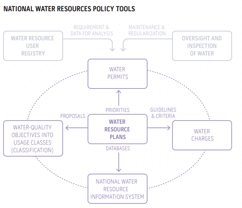
Brazil’s Integrated Water Resource Management is driven by the Política Nacional de Recursos Hídricos (PNRH), which establishes the principles for sustainable water use across the country. The Sistema Nacional de Gerenciamento de Recursos Hídricos (SINGREH) coordinates the management, bringing together governmental agencies, basin committees, and various stakeholders to ensure the equitable distribution of water, water conservation, and the monitoring of water quality.
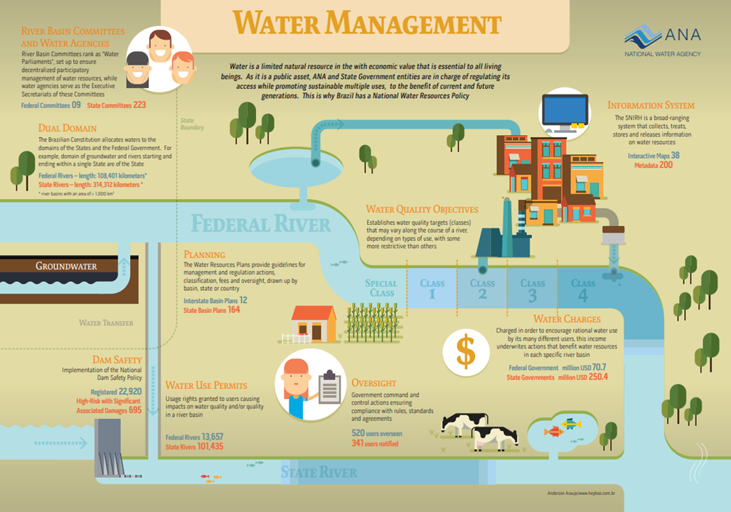
Key principles include:
- Decentralization: Decision-making is shared among federal, state, and local authorities, with participation from water users.
- Public participation: Basin committees involve government representatives, water users, and civil society, ensuring decisions reflect diverse interests.
- Economic value of water: Water use is regulated through economic instruments like water charges, which promote the efficient use of resources.
Integrated River Basin Management in Brazil is primarily managed through Comitês de Bacia Hidrográfica (Basin Committees), which are tasked with creating and implementing Planos de Recursos Hídricos (Water Resources Plans). These plans guide the sustainable use of water resources within specific river basins, balancing the needs of different sectors (agriculture, industry, and domestic users) with environmental conservation.
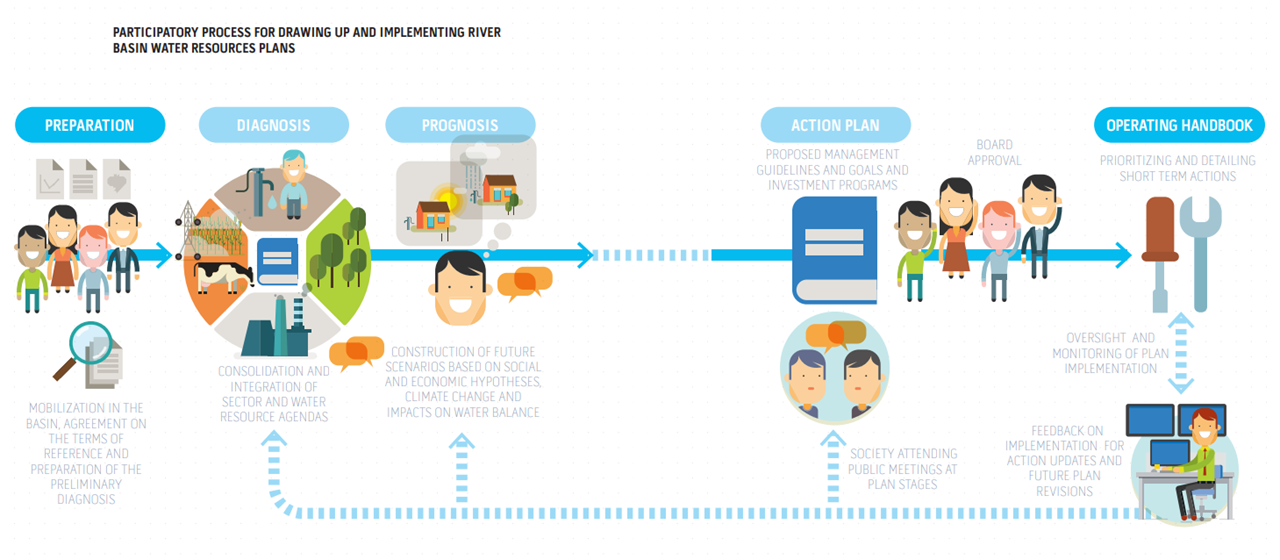
Each river basin in Brazil has its specific management plan based on the water availability and demands of the region. The committees also play a critical role in conflict resolution between competing water users.
WASH Policy (Water, Sanitation, and Hygiene)
Water
Safely Managed Water
Brazil’s water policy emphasizes providing access to safely managed water for all citizens. The Plano Nacional de Saneamento Básico (Plansab) and the Brazil’s Sanitation Legal Framework, established in 2020 through Federal Law No. 14,026, sets the target for achieving universal access to clean and safely managed drinking water by 2033. However, challenges remain in rural areas and underserved urban areas, where water access is still limited.
Basic Water Services: Basic water services include the provision of piped water to households, wells, and community water points. According to the latest data, approximately 97% of Brazil’s urban population has access to improved water services, but access is much lower in rural areas.
Challenges
- Geographic Disparities: The distribution of water resources is uneven, with the Amazon region holding the majority of the country’s freshwater, while the semi-arid Northeast suffers from chronic water shortages.
- Financial and infrastructure gaps: There is a need for significant investment to expand water infrastructure in rural and remote areas.
Climate Change Impact: Climate change poses a significant threat to water resources, causing more frequent and intense droughts, particularly in the Northeast. Rising temperatures and changing precipitation patterns affect water availability, making it harder to meet growing demands.
Sanitation
Safely Managed Sanitation Goals
The Plano Nacional de Saneamento Básico (Plansab) and Brazil’s Sanitation Legal Framework, established in 2020 through Federal Law No. 14,026, also sets ambitious goals to provide universal access to safely managed sanitation by 2033. This involves ensuring that sewage is collected, treated, and safely disposed of without contaminating water sources.
Basic Sanitation Efforts
Despite progress, basic sanitation services are still lacking for a significant portion of the population, particularly in rural areas. As of recent estimates, around 51% of Brazil’s population is connected to adequate sewage systems.
Sewers, Septic Tanks, etc
- Sewer Systems: Urban areas, particularly in large cities, are increasingly covered by sewer networks that collect wastewater for treatment.
- Septic Tanks: In rural areas, septic tanks remain a common solution, but their effectiveness is often limited by poor maintenance and insufficient capacity, leading to contamination risks.
Hygiene
Handwashing Facilities: Access to handwashing facilities with soap and water is critical for reducing disease transmission. The national goal is to ensure that every household and public space, including schools and healthcare facilities, has access to basic hygiene services.
Basic Hygiene Service: Brazil has made significant progress in providing basic hygiene services, but challenges persist in rural areas where access to safe and reliable water sources is limited. Handwashing is a key component of Brazil’s public health initiatives, particularly in response to disease outbreaks such as COVID-19.
Health and Education
Child Mortality
Access to clean water and sanitation has contributed to a reduction in child mortality rates in Brazil. However, in regions where WASH services are inadequate, waterborne diseases remain a significant cause of child mortality.
Human Development Index (HDI)
WASH services are integral to improving the Human Development Index (HDI) in Brazil. Regions with better access to clean water and sanitation, such as the Southeast, tend to have higher HDI scores than areas like the Northeast, where infrastructure gaps persist.
WASH-related Deaths
Inadequate water, sanitation, and hygiene services contribute to preventable diseases such as diarrhea, which still accounts for a considerable number of deaths in children under five in Brazil’s poorest regions.
Education Facilities: Many schools in Brazil still lack adequate WASH facilities, particularly in rural areas. Ensuring that all schools have clean drinking water, proper sanitation, and handwashing stations is a national priority, as poor WASH conditions can lead to absenteeism and negatively affect educational outcomes.
Transboundary Agreements on Water

Brazil shares several transboundary river basins with neighbouring countries, including the Amazon Basin, the Paraná Basin, and the La Plata Basin. These basins are subject to international agreements to promote integrated management of water resources, maintain environmental sustainability, and avoid conflicts.
Brazil has agreed on projects focusing on water resources management with most neighboring countries and promoted technical cooperation initiatives regional, which undertake efforts to integrate hydrological monitoring, training, exchange of data and information, among other actions.
Key agreements and collaborations include:
Treaty of the La Plata Basin
A cooperation agreement between Brazil, Argentina, Bolivia, Paraguay, and Uruguay to promote the sustainable use of water resources in the La Plata Basin.
Amazon Cooperation Treaty Organization (OTCA)
A framework for cooperation between Amazon basin countries (Brazil, Bolivia, Colombia, Equador, Guiana, Peru, Suriname and Venezuela) to implement actions and strategies to ensure integrated and sustainable resource management transboundary water resources of the Amazon River Basin considering Variability and Climate Changes.
These agreements ensure that water management practices respect both national interests and the shared environmental goals of the region.
Cooperation and other relevant aspects
Multi-Stakeholder Collaboration
In Brazil, multi-stakeholder collaboration on water, river basins, aquatic ecosystems, etc. within the country is a cornerstone of water resource management, guided by the principles of the Política Nacional de Recursos Hídricos (PNRH). Various actors, including governmental agencies, private sector companies, civil society, academia, and international organizations, collaborate to manage water resources sustainably, protect aquatic ecosystems, and manage river basins.
Key mechanisms supporting collaboration
- Comitês de Bacia Hidrográfica (Basin Committees): These are multi-stakeholder platforms that include government representatives, private sector actors (such as agribusiness and hydropower companies), civil society, and water users. They work together to implement water resource management plans (Planos de Recursos Hídricos) at the river basin level, addressing issues like water allocation, pollution control, and conflict resolution.
- Agência Nacional de Águas e Saneamento Básico (ANA): ANA plays a central role in coordinating these efforts by ensuring that different stakeholders are involved in decision-making processes, including those related to hydrological monitoring, water pricing, and management of aquatic ecosystems.
Commitments
Commitments within these multi-stakeholder collaborations include:
- Sustainable Water Use: Ensuring that water resources are used sustainably for agriculture, industry, and human consumption, while protecting aquatic ecosystems and maintaining water quality.
- Equitable Water Allocation: Basin committees and regulatory bodies like ANA focus on equitable water distribution, ensuring that all users (urban, rural, industrial, and agricultural) have fair access to water.
- Ecosystem Protection: Stakeholders work together to protect sensitive ecosystems like the Amazon Basin and the Pantanal wetlands, ensuring that water use does not compromise the integrity of these critical environments.
Mutual accountability mechanisms
Mutual accountability mechanisms in Brazil’s water sector are embedded in the Sistema Nacional de Gerenciamento de Recursos Hídricos (SINGREH), which encourages transparency and the participation of all stakeholders:
- Water Charging Systems: This mechanism ensures that water users pay for the water they consume, creating financial accountability. The funds collected from water charges are reinvested in water management projects, infrastructure, and environmental protection.
- Monitoring and Reporting: Through basin committees, regular monitoring of water use and quality is conducted, and all stakeholders are held accountable for meeting water resource management goals. ANA also plays a significant role in enforcing compliance and ensuring that water permits are respected.
- Conflict Resolution Mechanisms: Basin committees provide a platform for resolving conflicts over water use, ensuring that all voices are heard and equitable solutions are found.
Finance and Inequalities
The WASH (Water, Sanitation, and Hygiene) budget per capita in Brazil varies across regions, reflecting the disparities in infrastructure development and investment needs. Urban areas generally have higher investment in WASH services, while rural and underserved areas face financial constraints, leading to significant inequalities in access to clean water and sanitation. Although Brazil has committed to expanding WASH services, substantial funding gaps remain, particularly for achieving universal access by 2033, as outlined in the Plano Nacional de Saneamento Básico (Plansab).
Brazil’s national strategy on reducing inequalities in WASH services access, under the framework of Plansab, emphasizes reducing inequalities in access to clean water and sanitation by focusing on:
- Rural and Low-income Communities: Special efforts are being made to expand infrastructure in remote rural areas, where WASH access is most limited. These areas suffer from a lack of piped water, inadequate sewage treatment, and lower hygiene standards.
- Urban Informal Settlements: In urban areas, informal settlements (favelas) often lack proper water and sanitation services. Investment is being directed toward improving infrastructure in these areas, ensuring that all residents have access to basic WASH services.
- Indigenous and Vulnerable Populations: Indigenous communities and other marginalized groups are also prioritized in the national WASH strategy, with dedicated programs to ensure access to safe drinking water and sanitation services.
Space policy, Economy, and Space Law
The Law 8,854, enacted on February 10, 1994, establishes the Brazilian Space Agency (AEB) as an autonomous public entity linked to the Presidency of the Republic. This law defines the AEB's primary functions, including formulating and implementing Brazil's National Space Policy.
It mandates the agency to coordinate the development of national space programs and promote technological advancements in space activities. The AEB is also responsible for fostering international cooperation, regulating the commercial use of space activities, and ensuring that Brazil's strategic and defense interests in the space sector are protected.
The law highlights the need for Brazil to achieve technological autonomy in satellite systems, launch vehicles, and space infrastructure. Additionally, it grants the AEB the authority to create partnerships with private and public sectors to advance the country's space capabilities.
The National Policy for the Development of Space Activities (PNDAE), Law 1.332, December 8th 1994 (https://www.planalto.gov.br/ccivil_03/decreto/1990-1994/d1332.htm), established by the Brazilian Space Agency (AEB), aims to promote the country's technological autonomy and sovereignty in the space sector. The policy integrates space activities into national development strategies, supporting sectors like agriculture, water resource management, environmental monitoring, and national security.
The PNDAE emphasizes Brazil's role in international partnerships, encourages private sector participation, and fosters the development of space infrastructure, including satellites, launch vehicles, and spaceports like the Alcântara Space Center. It also aligns with the Sustainable Development Goals (SDGs), leveraging space technology to address challenges such as climate change, disaster prevention, and water resource management.
Water Resource Management with Space Technologies
The use of space technologies, such as Earth observation satellites, is essential for monitoring water resources, including rivers, lakes, groundwater, and water levels in various watersheds. This is particularly relevant for addressing challenges such as water scarcity, droughts, floods, and the sustainable management of resources in areas with limited data availability. The sector contributes to the Sustainable Development Goals (SDGs), especially SDG 6, which aims to ensure the availability and sustainable management of water and sanitation for all.
Challenges
- Aquifer Monitoring: Uses satellites to manage transboundary aquifers in Africa, essential for water supply in arid regions.
- Natural Disaster Forecasting: Projects to predict drought and flood conditions, improving disaster response.
- Capacity Building: Initiatives to train professionals in developing countries in the use of remote sensing data.
Projects, Initiatives, Satellite Missions
Brazil has been using space technologies to monitor, manage, and protect its water resources, utilizing satellite data to address challenges related to water scarcity, pollution, and climate change. Below are the key projects, initiatives, and missions in this area:
Earth Observation Satellites and Missions
- CBERS (China-Brazil Earth Resources Satellite): This cooperation program between Brazil and China, initiated in the 1980s, focuses on environmental monitoring, including deforestation control, water resource management, and agriculture. The CBERS satellites provide images used to monitor water bodies, assess water quality, and map flood and drought areas.
- Amazônia-1: The first Earth observation satellite entirely designed and manufactured in Brazil, launched in 2021. It is used to monitor the Amazon rainforest, providing important data on vegetation coverage and the hydrological cycle in the region, which is essential for watershed management.
Water Resource Management Initiatives
- Monitoring of Rivers and Watersheds: Brazil uses satellites to monitor large basins such as the Amazon and São Francisco, focusing on changes in water flow and environmental impact. This information helps identify flood risks and evaluate the effectiveness of conservation policies.
- Natural Disaster Prevention Projects: Remote sensing data is used to improve the response to extreme weather events like floods and droughts. This includes using models to predict river behavior during periods of intense rainfall or water scarcity, enabling more effective mitigation actions.
Partnerships and International Cooperation
Governmental and Space Agencies
- Technology Safeguards Agreement with the USA: This agreement facilitates the commercialization of the Alcântara Space Center for international launches, allowing Brazil to expand its capabilities and attract investment in the space sector. The cooperation also enables the development of new technologies and missions, including those focused on natural resource management, such as water.
- Partnership with China and Other Countries: Collaboration with China through the CBERS program and other nations allows for the exchange of technologies and knowledge to improve water resource monitoring and responses to natural disasters.
- NASA: Conducts water quality monitoring and drought forecasting projects, such as the SMAP mission, which analyzes soil moisture.
(International) Intergovernmental Organisations
- European Space Agency (ESA): The TIGER initiative, for example, supports transboundary water resource management in Africa.
- UNOOSA: Through the Space4Water project, promotes the use of space technologies for sustainable water management, with a focus on developing countries. (https://www.space4water.org/news/register-fourth-space4water-stakeholder-meeting)
Private Sector and NGOs
- World Resources Institute (WRI) and WWF: Use satellite data to assess global water risks and develop sustainable management strategies.
Challenges and Opportunities
The main challenges for Brazil in using space technologies for water management include developing its own infrastructure and strengthening public policies that integrate satellite data usage. On the other hand, the opportunities are vast, including improved management of large watersheds, disaster prevention, and the preservation of sensitive areas like the Amazon.
The adoption of space technologies is a vital tool for addressing environmental and natural resource challenges in Brazil, supporting sustainable development and water security.
Space Law and International Cooperation
Brazil's space economy has the potential for expansion with the growing participation of private companies in satellite-based technological services. In the legal field, the General Space Law project was approved on July 10, 2024. This law encourages space activities with Brazilian participation. The text includes regulations for space exploration, including private sector investments. The law establishes appropriate divisions for the military sector, the civil sector, and private sector entry. This will drive advances in satellite, rocket launchers, and launch and control infrastructure.
https://www25.senado.leg.br/web/atividade/materias/-/materia/163442
Government
1. Ministério de Ciência, Tecnologia e Inovação (MCTI)
Roles and Responsibilities: MCTI is Brazil’s Ministry of Science, Technology, and Innovation and develops national policies, funds research, and fosters innovation in science, technology, and climate resilience, while promoting collaborations for sustainable development.
Water-Related Challenges: MCTI contributes to addressing water-related challenges in Brazil by supporting research on hydrological systems, water resource management, and climate change impacts. It works closely with institutions like CEMADEN to develop technologies for monitoring and managing water-related disasters, such as floods and droughts, and promotes sustainable use of water resources to mitigate the effects of climate change.
1.1. Agência Espacial Brasileira (AEB)
Roles and Responsibilities: AEB is Brazil's Space Agency, which operates under the Ministry of Science, Technology, and Innovation (MCTI). The AEB is responsible for developing and coordinating Brazil's space activities, including satellite programs that support environmental monitoring, climate research, and disaster management.
Water-Related Challenges: AEB addresses water-related challenges by using satellite technology to monitor water resources, detect droughts and floods, and support climate change adaptation efforts.
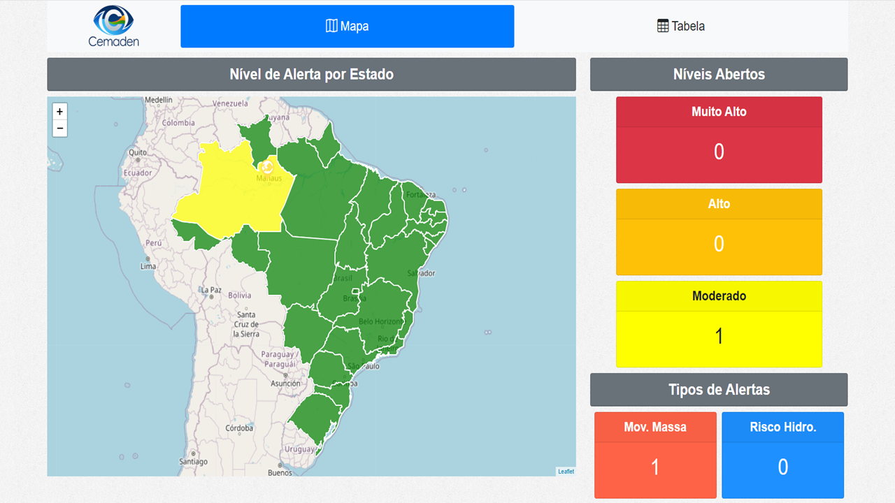
1.2. Centro Nacional de Monitoramento e Alertas de Desastres Naturais (CEMADEN)
Roles and Responsibilities: CEMADEN is Brazil's National Center for Monitoring and Alerts for Natural Disasters, which is part of the Ministry of Science, Technology, and Innovations (MCTI). CEMADEN monitors natural hazards, provides early warning systems, conducts research on disaster risk management, and promotes public awareness to reduce the impact of natural disasters in Brazil.
Water-Related Challenge: CEMADEN addresses challenges like floods and droughts by monitoring water-related disasters, issuing timely alerts, and collaborating with other institutions to mitigate their impact.
1.3. Instituto Nacional de Pesquisas Espaciais (INPE)
Roles and Responsibilities: INPE is Brazil's National Institute for Space Research, operating under the Ministry of Science, Technology, and Innovation (MCTI). INPE monitors environmental changes, conducts climate research, develops satellite technology, and collaborates internationally to support sustainable development and disaster prevention.
Water-Related Challenges: INPE addresses water-related challenges by using satellite data and remote sensing to monitor water resources, detect droughts and floods, and assess the impact of climate change on water systems.
1.3.1. Laboratório de Instrumentação de Sistemas Aquáticos (LabISA)
Roles and Responsibilities: The Instrumentation Laboratory for Aquatic Systems (LabISA) was created in 2013 at the National Institute for Space Research (INPE), motivated by the increasing number of studies focused on: i) the application of remote sensing for assessing physical, chemical, and biological properties of inland waters; ii) by recent technological advances and; iii) by the growing demand of the rational use of fresh water.
Water-Related Challenges: The main LabISA activity focuses on gathering in situ data on optical and limnological properties of Brazilian inland and coastal waters for: 1)To build a Brazilian bio-optical inland and coastal waters dataset for characterization and to support studies in aquatic environments; 2) Develop and calibrate bio-optical models to estimate water quality parameters from remote sensing; 3) Develop studies to evaluate the impacts of anthropogenic activities on the degradation of water resources (eutrophication, pollution, biodiversity, etc.); 4) Validate acquired orbital data on aquatic environments and 5) To train human resources in a highly relevant line of research for monitoring aquatic environments.
1.4 Instituto Brasileiro de Geografia e Estatística (IBGE)
Roles and Responsibilities: IBGE (Institute of Geography and Statistics of Brazil) is the official agency responsible for producing and disseminating statistical, geographic, cartographic, and demographic information in Brazil. Its roles include conducting national censuses, such as the population, agricultural, and economic censuses, which are essential for public policy planning and decision-making. The IBGE also monitors economic indicators, including inflation, GDP, and employment rates, providing a comprehensive overview of Brazil’s economic performance. Additionally, it develops and maintains geographic maps and databases that support urban planning and environmental management.
Water-Related Challenges: To produce and make available timely updated data related to municipal surveys, censuses and sample surveys related to water use, as well as maps and cartographic and hydrographic division databases.
SDG Reporting
Country overview
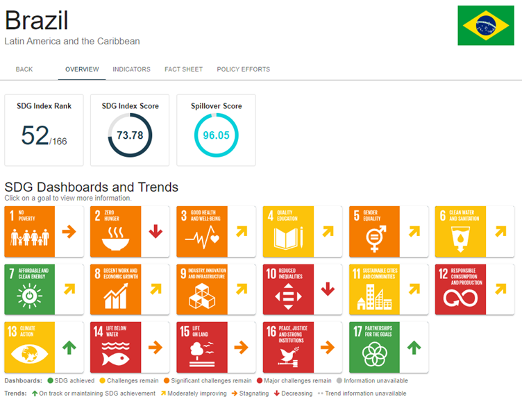
Brazil ranks 52nd out of 166 countries in the 2024 SDG Index with a score of 73.78. The country faces significant challenges in achieving several SDGs, particularly in areas such as zero hunger (SDG 2) and Reduced Inequalities (SDG 10). and climate action (SDG 13). While some progress has been made, particularly in health and education, other areas like sustainable cities (SDG 11) and responsible consumption (SDG 12) show major challenges. The overall trend indicates moderate improvement across several goals. Spillover effects remain a concern, with Brazil scoring 96.05.
Voluntary National Review – Brazil 2024
The Voluntary National Review (https://www.gov.br/secretariageral/pt-br/cnods/RNV_Brasil/english/VNR_BRAZIL_FULL.pdf) is a form of monitoring the implementation of the Sustainable Development Goals (SDGs). This report can be presented to the UN by countries that have committed to the 2030 Agenda.
Reinforcing the Brazilian government's efforts to strengthen the 2030 Agenda, President Lula has committed to preparing and presenting a report, as the last one the country submitted was in 2017.
The preparation of the Voluntary National Review (VNR) was coordinated by the National Commission for Sustainable Development Goals (CNODS), which is linked to the Executive Secretariat of the General Secretariat of the Presidency of the Republic, with the participation of several institutions such as IPEA, IBGE, Fiocruz, Itaipu Binacional, the Ministry of Planning and Budget, and the Ministry of Foreign Affairs.
More than just a transparency tool, this is a mobilization process, as it allows the Brazilian state to identify the efforts of civil society and all levels of government in implementing the goals and targets that integrate the dimensions of sustainable development.
The United Nations encourages countries to present their reports regularly at the High-Level Political Forum (HLPF), which takes place annually in July in New York, at the UN headquarters.
The federal government presents to the UN a synthesis of the best experiences currently underway in Brazil, building a report that reflects the country's diversity. To achieve this, CNODS has opened public consultations to hear from different sectors of society.
The Voluntary National Review will address Brazil's efforts concerning the 17 Sustainable Development Goals (SDGs), highlighting the policies and programs implemented, the challenges faced, and the future outlook for achieving the goals set out by the 2030 Agenda.
Commitments by the government
In Brazil, the governance of the 2030 Agenda is coordinated and articulated by the Secretariat of Government of the Presidency of the Republic (SEGOV-PR). Decree No. 10,591, dated December 24, 2020, established the responsibility of the Special Secretariat for Social Articulation (SEAS/SEGOV) to assist the Chief Minister in matters related to the implementation of international commitments and agreements to which the country is a signatory.
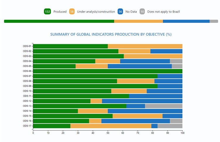
The UN maintains a platform to disseminate SDG 6 data globally. Through its Custodian Agencies, the indicators are periodically updated with countries by conducting workshops, email exchanges with focal points, and sending and receiving data collection forms.
Monitoring SDG 6 indicators is an ongoing effort carried out by ANA in partnership with other agencies such as the Brazilian Institute of Geography and Statistics (IBGE), responsible for monitoring all 17 SDGs, as well as the Ministry of Health (MS), the Ministry of Regional Development (MDR), and the Geological Survey of Brazil (CPRM). The governance of the 2030 Agenda in Brazil is coordinated by the Secretariat of Government of the Presidency of the Republic (SEGOV-PR).
In Brazil, most of the SDG 6 indicators have ANA as the focal point for updating, monitoring, and communicating with Custodian Agencies. For some indicators, ANA works in an integrated manner with IBGE, MS, MDR, and CPRM.
The National Water and Basic Sanitation Agency (ANA) is the central institution in Brazil responsible for water resource management and for defining reference standards for the provision of basic sanitation services. ANA systematically and periodically monitors the condition of water resources and their management in the country through statistics and indicators that feed the National Water Resources Information System (SNIRH).
In 2019, ANA launched the first edition of the report SDG 6 in Brazil: ANA's Vision on the Indicators. In 2022, ANA presented the second edition of this publication, containing updates of historical series of indicators and improvements in their calculation due to methodological advancements and new available data. Each indicator has a specific process for calculation and updating, both in terms of guidance and data collection by the UN custodian agencies and the availability of more current data.
ANA implements the National Water Resources Policy, coordinates the National Water Resources Management System, and establishes reference standards for regulating basic sanitation services (under new responsibilities defined by Law No. 14,026 of 2020).
Water resource management in Brazil is relatively recent. The National Water Resources Management System (SINGREH), created and instituted by the 1988 Federal Constitution of Brazil, involves various agencies, entities, and civil society. It is regulated by Law No. 9,433 of 1997, which established the National Water Resources Policy, its foundations, objectives, and instruments. ANA is the central agency that coordinates this management and regularly presents information, statistics, and indicators to identify the results of this public policy implementation in the country and to monitor the National Water Resources Plan (PNRH).
This information is stored in the database that feeds the National Water Resources Information System (SNIRH) and supports the preparation of the annual Water Resources Situation Report in Brazil. This report is the reference for monitoring the water situation and management in the country. Its preparation involves the partnership of agencies and entities that are part of SINGREH, as well as other federal and state public agencies that form a broad network supporting the calculation of SDG 6 indicators.
SDG reporting on water-related indicators
Progress on Water and Sanitation Indicators
- Access to Drinking Water (Indicator 6.1.1): Brazil has made substantial progress in providing access to safely managed drinking water services. Currently, 97.4% of the population has access to improved drinking water services, with 77.4% of the population receiving piped water.
- Sanitation Services (Indicator 6.2.1): Brazil has shown significant improvement in providing safely managed sanitation services. 63.1% of the population has access to safely managed sanitation, although there are still regional disparities and challenges in reaching 100% by 2030. This area has seen one of the highest increases, with 47.8 million people gaining access between 2009 and 2019.
Key Challenges
- Wastewater Treatment (Indicator 6.3.1): Wastewater treatment remains a challenge, with only 62% of anthropogenic wastewater receiving proper treatment. Reducing inequalities, especially in rural and socioeconomically vulnerable areas, is crucial for improving this indicator.
- Water Stress and Use Efficiency (Indicators 6.4.1 and 6.4.2): Brazil has been making efforts to increase water-use efficiency and manage water stress levels, but there is still work to be done to ensure sustainable freshwater withdrawals.
- Gender Inequality in Water Access: The issue of gender equality in accessing safely managed drinking water and sanitation was found to be a weak point in the national policy framework, particularly in reaching vulnerable populations, such as women and indigenous communities.
Areas with Positive Development
- Water Quality Improvement (Indicator 6.3.2): Significant advancements have been made in monitoring water quality, with better data collection and systematization for assessing the quality of water bodies.
- International Cooperation (Indicator 6.a.1): Brazil is actively involved in expanding international cooperation for water resource management and has been recognized as a regional hub for SDG 6 implementation.
Governance and Financing Gaps
- Governance: Nearly 63% of the fields analyzed in the governance component were assessed as "in progress" or "inadequate," indicating that policy implementation needs improvement.
- Finance: While 50% of the finance-related evaluations were considered "adequate," the report highlights that there is insufficient financing to fully achieve the SDG 6 targets.
SDG 6 in Brazil – ANA´s Vision of the Indicators
ANA has updated indicators, including historical series and disaggregations in different spatial breakdowns. These updates were carried out with the UN Custodian Agencies, with participation in international workshops for methodological harmonization and experience sharing among countries. It is noteworthy that ANA, as the focal point in Brazil, has worked with agencies to improve the indicator calculation methodology, acting as a specialist in the Target Group for SDG 6.4 and as a pilot country for spatial disaggregation of indicator 6.4.2 (Water Stress Level).
For the second edition of the report SDG 6 in Brazil: ANA's Vision on the Indicators (2022), various forms of indicator updates were made. Some indicators were updated using the same methodologies and data sources as in the first edition (e.g., 6.4.2 and 6.a.1), while others underwent changes in their calculation method or data sources used. Considering the methodologies, some indicators were modified by the Custodian Agency itself (e.g., 6.4.1, 6.6.1, and 6.b.1), while others were updated by the focal point aiming at improvements in the calculation for the country (e.g., 6.1.1, 6.2.1a, 6.2.1b, 6.3.1, 6.3.2, 6.5.1, 6.5.2).
These findings indicate that while Brazil has made significant progress in certain areas, there remain substantial challenges, particularly in the areas of gender equity, wastewater treatment, and governance.
Use of space-based technologies and applications to address water issues and to monitor SDG indicators in Brazil
The SDG 6.1 App is a global platform designed to track progress on Sustainable Development Goal 6 (SDG 6), which focuses on ensuring the availability and sustainable management of water and sanitation for all. This platform provides data, tools, and resources to help countries, organizations, and individuals monitor and accelerate progress toward achieving the water-related targets of the SDGs.
Key Features and Functions
- Data Visualization and Monitoring: The SDG 6.1 app offers detailed data visualization tools that allow users to track key indicators related to access to clean drinking water, sanitation services, and water management across different countries. It provides real-time data on various aspects of water availability, sanitation coverage, and water use efficiency.
- Country Progress Reports: The app enables users to view country-specific progress reports, providing insights into how nations are performing on specific SDG 6 targets. Users can compare different countries’ progress on achieving clean water and sanitation goals, as well as identify areas where more attention or resources are needed.
- Decision-Support Tools: The platform offers decision-making support tools designed to help governments and organizations assess gaps, make informed policy decisions, and prioritize actions to accelerate SDG 6 progress. It includes resources to aid in planning, resource allocation, and implementation of water and sanitation strategies.
- Collaboration and Sharing: The SDG 6.1 app promotes collaboration by allowing users to share best practices, case studies, and success stories on water management and sanitation projects. It fosters international cooperation by highlighting successful projects and policies that could be adapted in different regions.
- Access to Global Water and Sanitation Data: The app aggregates data from various international sources such as the UNICEF-WHO Joint Monitoring Programme (JMP) and other global databases to provide comprehensive insights into water resource management, sanitation services, and wastewater treatment.
Application in Brazil
Brazil uses the SDG 6.1 platform to monitor its progress on water and sanitation goals, such as ensuring universal access to safely managed water services and improving sanitation infrastructure. The app provides valuable insights into areas where Brazil is performing well and highlights specific challenges, like water scarcity in certain regions and gaps in sanitation services. Through the platform, Brazil can assess the impact of its policies and compare its progress with other countries.
The SDG 6.1 application operates with global resolution, providing an overview of water and sanitation data across countries. However, to improve the accuracy and relevance of the data for specific regions, it is essential to calibrate the app using local data. Incorporating detailed, region-specific information allows for more precise tracking of progress on water-related SDGs, helping to identify challenges and make more informed decisions at the local level. This calibration is crucial for enhancing the quality and reliability of the data, ensuring that it accurately reflects the realities of water management and sanitation services in each country.
Strategically, it would be advantageous for ANA to collaborate with the United Nations to calibrate the existing SDG 6.1 app rather than developing its own separate application.
Working together with the UN has several benefits:
- Leverage Global Standards: The UN's SDG 6.1 app is built on global standards and frameworks, which would ensure that Brazil’s data is aligned with international benchmarks. By contributing to the calibration of this platform, ANA can ensure that Brazil’s local data is integrated seamlessly into a globally recognized system.
- Resource Efficiency: Developing a separate app would require significant time and financial resources. Collaborating with the UN allows ANA to avoid duplicating efforts, enabling it to focus its resources on data collection, monitoring, and improving water resource management.
- Enhanced Data Accuracy: By working with the UN, ANA can contribute local data that will refine the global app's accuracy for Brazil’s context. This calibration ensures that the app reflects Brazil’s specific challenges and progress in water and sanitation, improving the overall quality of data-driven decision-making.
- Global Visibility and Influence: Partnering with the UN allows ANA to contribute to a tool that has global visibility, reinforcing Brazil’s leadership role in water management. ANA’s involvement would also allow it to influence the development of the app, ensuring it better serves national interests.
In summary, collaborating with the UN to calibrate the existing app would be a more strategic move for ANA, offering greater global alignment, efficiency, and influence while improving the quality of water and sanitation data for Brazil.
Space and water related actors, projects, missions, initiatives, community portals, software, tools models and APIs in Brazil
1. Agência Nacional de Águas e Saneamento Básico (ANA)
Software/Tools/Models/API:
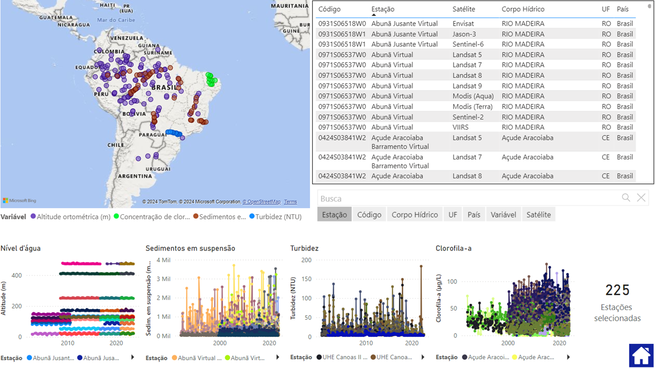
HidroSat
Earth Surface Point Inspection App - esPIA
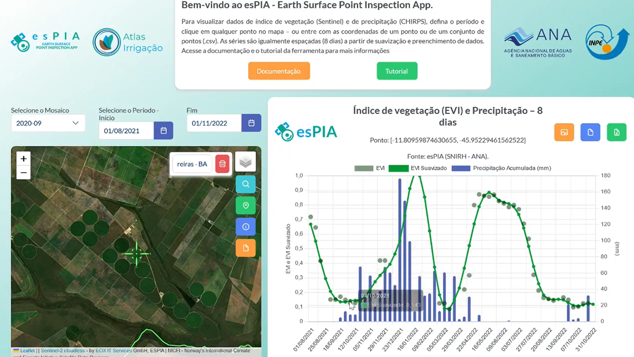
- Description: Web Application Aimed at Agricultural Monitoring of Irrigable Areas based on multitemporal analysis of EVI- Enhanced Vegetation Index from the Sentinel 2 constellation, precipitation data from Chirps, and basemaps
- Type of Software: Web Application
- Functionality (features): web map and temporal series analysis application
- Supported Standards: n/a
- License: n/a
- Installation: not required (web app)
- Payment: free for users at the National Water Information System Portal (SNIRH)
- Video: https://www.youtube.com/watch?v=Rkh5a5GjOhw
- Authors: Hugo Bendini, Daniel Assumpção Costa Ferreira, Thiago Henriques Fontenelle, Leila Maria Garcia Fonseca, Luiz Mario Lustosa Pascoal, Tharles de Sousa Andrade, Renato Gomes Silvério, Caio Augusto Bertolini
- Organization: Partnership between ANA – National Water and Sanitation Agency (Brazil) and INPE- National Institute for Space Research (Brazil)
- Capacity Building / Training Material: training courses on data processing have been offered by ANA and INPE on a demand-basis.
- Thematic Focus: Water Use, Land Use, Monitoring Irrigates Areas, and Agricultural Dynamics (temporary crops rotation)
- Regional Focus: National (Brazil)
- Contact details: https://espia.snirh.gov.br, Thiago Henriques Fontenelle (thiago.fontenelle@ana.gov.br), Daniel Assumpção Costa Ferreira (daniel.ferreira@ana.gov.br)
2. Serviço Geológico do Brasil (SGB)
Software/Tools/Models/API:
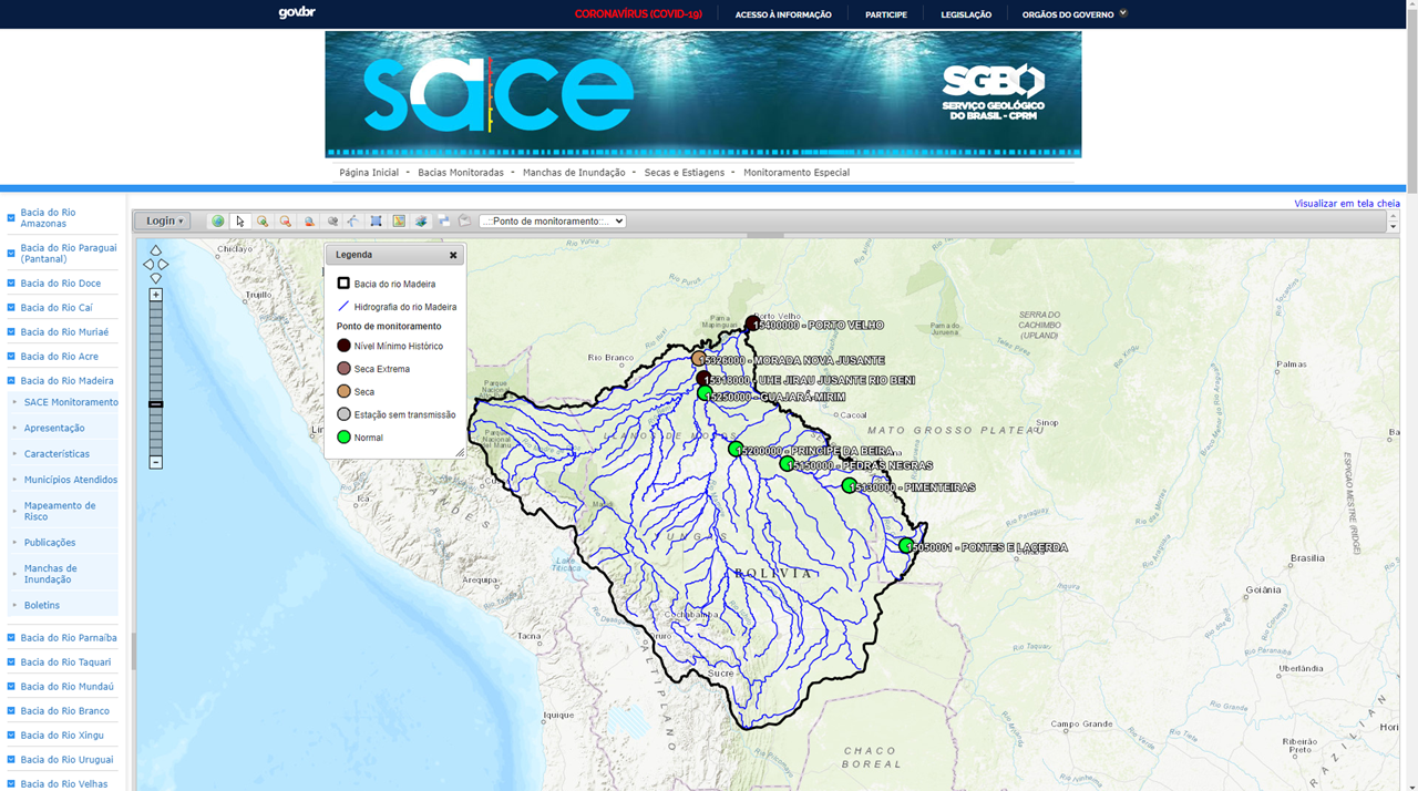
- Title (Acronym): - Sistema de Alerta de Eventos Críticos (SACE) – Extreme Events Alert System
- Description: Extreme Events Alert System (SACE) is a web-based platform developed by the Serviço Geológico do Brasil (SGB) to monitor and issue alerts for flood risks and droughts in various river basins across Brazil. The system provides real-time data on river levels, precipitation, and hydrological forecasts to aid government agencies and communities in mitigating the impacts of floods and reducing disaster risks.
- Type of Software: web application: https://www.sgb.gov.br/sace/
- Functionality (features): Real-time monitoring of river water levels and rainfall; Flood risk alerts based on hydrological forecasts; Interactive maps showing flood-prone areas; Historical data analysis for river flow and precipitation; Integration with meteorological and hydrological data sources; Customizable notifications for users based on river basins and water level thresholds
- Supported Standards: WMO Hydrological Standards; ISO 19115 (Geographic Information Metadata); OGC (Open Geospatial Consortium) standards for geospatial data
- License: Free to use (Public Government Service)
- Installation: No installation required; accessible through a web browser.
- Payment: Free to access; no payment required.
- Video: n/a
- Authors: Serviço Geológico do Brasil (SGB)
- Organization: Serviço Geológico do Brasil (SGB)
- Capacity Building / Training Material: Online training and user guides are available on the website for users and public officials to familiarize themselves with the system.
- Thematic Focus: Flood Monitoring, Drought, Disaster Risk Reduction, Hydrological Monitoring, Water Resource Management
- Regional Focus: Applies to river basins across Brazil, with a particular focus on regions prone to floods, such as the Amazon Basin, São Francisco Basin, and coastal regions.
- Contact details: Emanuel Duarte Silva (emanuel.duarte@sgb.gov.br) Daniel Medeiros Moreira (daniel.moreira@sgb.gov.br)
3. Centro Nacional de Monitoramento e Alertas de Desastres Naturais (CEMADEN)
Software/Tools/Models/API:
- Title (Acronym): Integrated Drought Index (IDI)
- Description: Cemaden’s Integrated Drought Index is composed of three parts: the Standardized Precipitation Index (SPI), Root Zone Soil Moisture (RZSM) and the Vegetation Health Index (VHI). The three components are based partially on remote sensing information. The index is presented in monthly meetings, bulletins, and an interactive platform.
- Type of Software: https://mapasecas.cemaden.gov.br/
- Functionality (features): The portal enables the users to select three versions of our drought index (1, 3 and 6 months), in addition to a product about potential impacts on agricultural areas.
- Supported Standards: n/a
- License: n/a
- Installation: n/a
- Payment: n/a
- Video: n/a
- Authors: Cemaden’s Drought Team
- Organization: Cemaden (National Center For Monitoring and Early Warning of Natural Disasters)
- Capacity Building / Training Material: n/a
- Thematic Focus: Drought Impacts
- Regional Focus: Brazil
- Contact details: @cemaden.secas 9instagram); https://falabr.cgu.gov.br Adriana Cuartas (adriana.cuartas@cemaden.gov.br) Larissa Silva (larissa.silva@cemaden.gov.br)
4. Instituto Nacional de Pesquisas Espaciais (INPE)
Software/Tools/Models/API:
Modular system for continuous monitoring of inland water quality by satellite (MAPAQUALI)
- Description: The MAPAQUALI project aims to develop a customizable modular system for continuously monitoring continental aquatic systems by remote sensing. The system proposes to generate and make available, for aquatic systems for which it is customized, time series of the spatial distribution of water quality parameters: Chlorophyll-a, Cyanobacteria, Total Suspended Solids, Dissolved Colored Organic Matter (CDOM), underwater light field through the diffuse attenuation coefficient (Kd) and alerts for bloom events (especially cyanobacteria).
- Type of Software: webapp (in preparation: https://brazildatacube.dpi.inpe.br/mapaquali/map)
- Functionality (features): Maps of water quality indicators are estimated from the integration of bio-optical algorithms, satellite images and field data.
- Supported Standards: n/a
- License: n/a
- Installation: n/a
- Payment: n/a
- Video: https://bit.ly/47pdVqx
- Authors: Claudio Barbosa (claudio.barbosa@inpe.br); Evlyn Novo (evlyn.novo@inpe.br) Daniel Maciel (daniel.maciel@inpe.br)
- Organization: LabISA - INPE
- Capacity Building / Training Material: n/a
- Thematic Focus: Water quality monitoring by remote sensing
- Regional Focus: Brazilian inland and coastal waters, Bio-optical indicators of water quality
- Related Documents: https://bv.fapesp.br/pt/auxilios/108461/desenvolvimento-de-sistema-modular-para-monitoramento-continuo-da-qualidade-de-aguas-interiores-por-/
- Contact details: Claudio Barbosa (claudio.barbosa@inpe.br)
Brazil Data Cube (BDC)
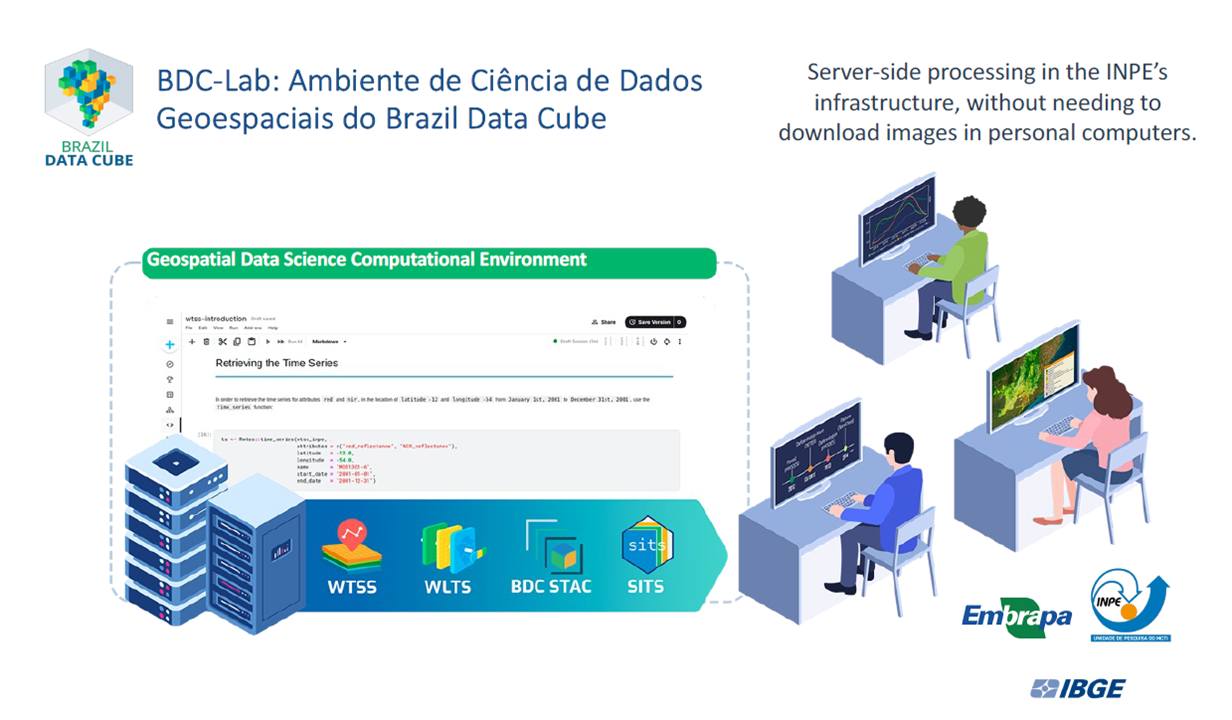
- Description: Brazil Data Cube is a research, development and technological innovation project of the National Institute for Space Research (INPE), Brazil. It is producing multidimensional data cubes from big volumes of medium-resolution remote sensing images for the entire Brazilian territory and developing a computational platform to process and analyze these data sets using artificial intelligence, machine learning and image time series analysis.
- Type of Software: A computational platform composed of web applications, APIs, web services and a data science lab environment.
- Functionality (features): Production, visualization and analysis of data cubes of remote sensing images using artificial intelligence (machine and deep learning) and image time series analysis.
- Supported Standards: STAC (SpatialTemporal Asset Catalog), OGC Web Services, ...
- License: Creative Commons Attribution-ShareAlike 4.0 International License
- Installation: https://data.inpe.br/bdc/web/en/home-page-2/#softwareproducts
- Payment: n/a
- Video: https://data.inpe.br/bdc/web/en/publications/
- Authors: Karine Ferreira et al. (karine.ferreira@inpe.br) https://data.inpe.br/bdc/web/en/earth-observation-data-cubes-for-brazil-requirements-methodology-and-products-en/
- Organization: National Institute for Space Research (INPE)
- Capacity Building / Training Material: https://data.inpe.br/bdc/web/en/code-gallery/
- Thematic Focus: Land use and land cover from remote sensing images
- Regional Focus: Brazil
- Related Documents: https://bv.fapesp.br/pt/auxilios/108461/desenvolvimento-de-sistema-modular-para-monitoramento-continuo-da-qualidade-de-aguas-interiores-por-/
- Contact details: Karine Ferreira (karine.ferreira@inpe.br)
TerraHidro
- Description: A platform for applications related to distributed hydrological modeling and hydrogeomorphological processes.
- Type of Software: Desktop software and Plugin QGIS
- Functionality (features): Digital Elevation Model (DEM) processing; Extraction of drainage networks from DEMs; Delineation of basins/minibasins; Extraction of floodplains from drainage networks; Codification of order of stream segments; Ottocodification of rivers and basins from drainage networks; Extraction of inundated areas from dam breaks, Modify the AgreeDEM on flat areas using the drainage network; Generates the otto codification of rivers from an D8 upstream flow directions grid, a drainage grid, contributing area grid and a mouths text file; Generates the otto codification of basins from an D8 upstream flow directions grid, a Otto rivers grid; Generates the main river from an D8 upstream flow directions grid, a drainage grid, contributing area grid and a mouth text file; Generates the Shreve stream order from an D8 flow directions grid, a drainage grid, and a sources text file; Generates the Strahler stream order from an D8 flow directions grid, a drainage grid, and a sources text file; Generates water courses from contributing areas.
- Supported Standards: OGC, GDAL (from Terralib API)
- License: Free software
- Installation: https://www.dpi.inpe.br/terrahidro/doku.php#download
- Payment: n/a
- Video: n/a
- Authors: Sergio Rosim (sergio.rosim@inpe.br), Henrique Rennó de Azeredo Freitas (henrique.renno@inpe.br)
- Organization: National Institute for Space Research (INPE)
- Capacity Building / Training Material: https://www.dpi.inpe.br/terrahidro/doku.php
- Thematic Focus: Distributed hydrological modeling and hydrogeomorphological processes.
- Regional Focus: DEM processing at large or small basin scale.
- Related Documents: https://bv.fapesp.br/pt/auxilios/108461/desenvolvimento-de-sistema-modular-para-monitoramento-continuo-da-qualidade-de-aguas-interiores-por-/
- Contact details: Sergio Rosim (sergio.rosim@inpe.br), Henrique Rennó de Azeredo Freitas (henrique.renno@inpe.br)
5. Mapbiomas Água
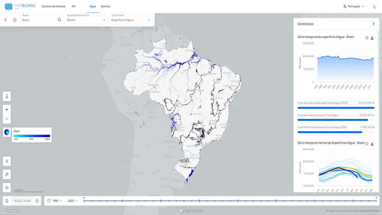
- Description: MapBiomas Água is a tool for monitoring and mapping water bodies across Brazil using satellite imagery and remote sensing data. It tracks historical changes in surface water coverage to assess water availability and identify trends linked to deforestation, agricultural expansion, urbanization, and climate change impacts.
- Type of Software: Web-based application
- Functionality (features): Monitoring of water bodies and water availability in real-time; Historical data on surface water changes from satellite imagery; Visualization and analysis tools for land and water use; Export of water-related data for external use and research; Data classification and validation with ground-level sources
- License: Open Access (Free to use, publicly available)
- Installation: No installation required; accessible via web browser: https://plataforma.brasil.mapbiomas.org/agua
- Payment: Free to access
- Video: No specific video provided for MapBiomas Água, but the main MapBiomas platform has several resources: https://www.youtube.com/user/mapbiomas
- Authors: MapBiomas Network (collaboration of multiple institutions including universities, research institutions, and NGOs)
- Organization: MapBiomas
- Capacity Building / Training Material: Training materials and tutorials are available on the MapBiomas website to help users navigate and utilize the tools effectively. Regular webinars and workshops are conducted for data users.
- Thematic Focus: Water Resource Monitoring; Environmental Conservation; Climate Change Impact; Deforestation and Land Use Monitoring
- Regional Focus: Brazil, with a focus on all major watersheds and water bodies across the country.
- Related Documents: MapBiomas provides technical reports and methodologies used for water body monitoring:
- Contact details: Email: contato@mapbiomas.org; Website: https://brasil.mapbiomas.org;