Transitioning from the Millennium Development Goals (MDGs) to the Sustainable Development Goals (SDGs)
The world of WASH (water, sanitation, and hygiene) has come a long way in 30 years. Between 1990 and 2015, 2.6 billion people gained access to improved drinking water, whilst 2.1 billion gained access to improved sanitation (Unicef and World Health Organisation 2015). That’s a lot of people. But is it enough?
In 2000, The MDGs, born out of the United Nations Millennium Declaration, delineated eight targets, which 191 UN Member States committed to help achieve by 2015 (Hulme 2009). Goal number 7: To ensure environmental sustainability, included the target of halving the proportion of the population without safe drinking water and basic sanitation. By 2010, the target for water had been met, whilst the target for sanitation had not. 2.4 billion people still lacked access to improved sanitation services, with coverage falling 9% short of the target (Figure 1) (Unicef and World Health Organisation 2015).

With much progress still needed to be made, The SDGs were adopted by all UN Member States in 2015 to further the work of the MDGs: a universal call to action to end poverty, protect the planet and ensure that all people enjoy peace and prosperity by 2030 (Pedersen 2018).
The current state of affairs
The SDGs are more inclusive and focus more holistically on development than the MDGs did (World Health Organization 2015). To progress from 2015 to the ambitious goals of the SDGs by 2030, including no poverty, zero hunger, and quality education for all, significant work must be done by every state, organisation, and individual.
SDG 6 (six targets focussing on WASH services, water scarcity, Integrated Water Resource Management (IWRM) and water-related ecosystems, and two targets focussed on their implementation) is much more in-depth than those targets outlined within MDG 7. Many countries have made rapid progress in access to WASH services, transforming lives, the environment, and their economies (United Nations 2020). However, if, as a global population we are to have universal and equitable access to safe and affordable drinking water, sanitation, and hygiene by 2030, we still have a very long way to go. According to the UN’s Sustainable Development Goal Report of 2020, unless current rates of progress increase substantially (Figure 2), SDG 6 targets will not be met.

SDG 6 comprises 12 indicators by which progress can be measured. Progress to date is as follows. In 2017, 71% of the global population used safely managed drinking water, whilst only 41% used safely managed sanitation services, with 60% having access to soap and water at home. This left 2.2 billion people (29%) without safely managed drinking water, 4.2 billion (55%) without safely managed sanitation, and 3 billion (40%) without a basic handwashing facility, as well as 673 million still practicing open defecation (United Nations 2020). Furthermore, over 80% of raw wastewater is still discharged into seas and rivers (UNOOSA 2018), compromising the quality of surface water bodies, whilst water quality data shortages mean that over 3 billion people are at risk as the health of their water sources are unknown. Regarding target 6.4 indicators, although water-use efficiency has increased by 4% since 2015, 2.3 billion people still live in water stressed countries. IWRM offers similarly concerning statistics, with 129 countries not on track to have sustainably managed water resources by 2030 and only 22 countries with operational arrangements for cooperation with neighbours for all of their rivers, lakes, and aquifers. Finally, 1/5 of the world’s river basins are experiencing rapid changes in the area covered by surface waters (UN water 2021). Evidently, much work stills needs to be enacted if the targets are to be met by 2030.
The collection of this data largely comes from on the ground via household surveys and administrative sources, alongside in-situ measurements such as those from boreholes and rain and stream gauging stations (Sheffield et al. 2018). Some data, however, is provided by space technologies. Further, The UN-Water Global Analysis and Assessment of Sanitation and Drinking-water (GLAAS) monitors targets 6a and 6b, which focus on the means of implementing targets 1-6. It provides information on governance, monitoring, human resources, and financing in the WASH sector required to sustain and extend WASH systems and services to all.
Despite the indicators, monitoring frameworks, and data collected thus far, progress appears to be limited due to a number of reasons. These include a lack of political will, weak regulatory institutions, competing demands from industry and agriculture, climatic changes, natural disasters, and population growth (United Nations 2020; Water Aid 2019; World Health Organization 2019). Furthermore, funding requirements severely threaten progress, so too does Covid-19 (UNICEF and WHO 2020; United Nations 2020). For example, according to United Nations (2020) some countries are experiencing a funding gap of 61% for achieving their water and sanitation targets by 2030.
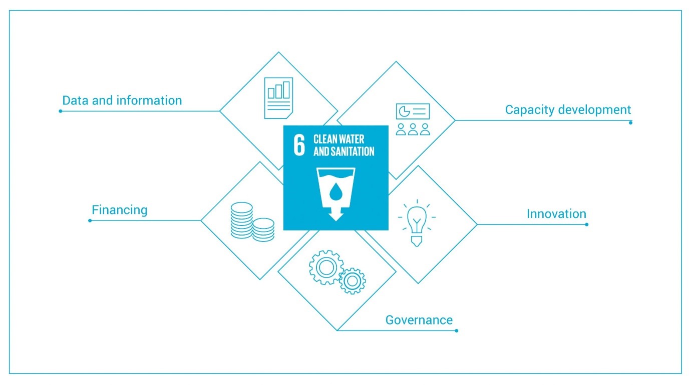
In order to address these discrepancies, The Sustainable Development Goal 6 Global Acceleration Framework was launched in 2020 to generate multi-stakeholder commitment to deliver fast results on water and sanitation (Figure 3). Action is being driven by five accelerators: finance, data and information, capacity development, innovation, and government (UN-Water 2020). Hopefully with such action, dedication, and hard work, the discrepancies currently seen in SDG 6 indicators will be eliminated. Only time will tell, however, whether these actions are sufficient or whether they are too little too late.
Space Technologies contribution to SDG 6
As already mentioned, one way in which data can be collected for the monitoring of SDG 6 indicators is via space technologies. Space technologies have been benefiting human development on Earth for over 60 years via telecommunications, global navigation satellite systems (GNSS) and Earth observation (EO) satellites and services (Oluwafemi and Olubiyi 2019). According to UNOOSA (2018), the synergy of the two European flagship programmes (European Global Navigation Satellite Systems (EGNSS) and Copernicus) directly benefit almost 40% of the SDG targets, either by helping to monitor the status of each target or by actively contributing to its fulfilment. SDG 6 has been classified as one of 13 goals that space technologies can make a “significant contribution” to (UNOOSA 2018).
Various space missions and associated technologies are assisting in the progress of SDG 6. The main targets that space technologies currently contribute to are: 6.1, 6.3, 6.4, 6.5, 6.6 and 6a. By reaching remote locations, and providing immediate transmission, periodic location revisitation and high-resolution remote sensing monitoring by space technologies can save money and time, providing much more comprehensive, accurate coverage than relying on ground-based measurements alone (Chuvieco 2016).
The protection of water-related ecosystems such as wetlands, mountains, forests, rivers, ground water aquifers and lakes (target 6.6) is the most tangible target to the application of space technologies. Through the use of satellite imagery, namely from Landsat 5, 7 and 8 and Sentinel 1 (radar) and 2 (optical), the spatial and temporal extent and changes in extent of such ecosystems are realised. The Global Surface Water Explorer (GSWE) is a dataset based on Landsat satellite imagery from the past 35 years, developed in order to help countries to report on these variables (Hannay 2020). The collection of soil moisture, optimally by microwave remote sensing, and ocean salinity data by missions such as Soil Moisture Active Passive (SMAP) and Soil Moisture and Ocean Salinity (SMOS) also aid in understanding the distribution and monitoring of these ecosystems (Charou et al. 2013). Such data provides insight into how the whole Earth system works as these properties are at the nexus of water, energy and carbon exchange between land and air, on which our Earth and its ecosystems are dependent (NASA 2014).

EO and GNSS is also used extensively to improve access to and sustainable use of the water resources these ecosystems provide (targets 6.1 and 6.4). For example, The Gravity Recovery and Climate Experiment (GRACE) and Follow-on (GRACE-FO) Missions help to mitigate the consequences of water scarcity by following the movement of groundwater on Earth by detecting changes in gravity, as groundwater cannot currently be directly measured from space (Figure 4). This enables the detection of water shortages, the identification of water sources, and the monitoring of groundwater levels, informing necessary action (Sun 2013). Similarly, the extent of surface water bodies can be identified and their fluctuations monitored, using both optical and microwave sensors, through missions such as Sentinel-2, advising on sustainable withdrawals and potential for improved efficiency (Sheffield et al. 2018). Furthermore, obtaining precipitation forecasts with, for example, Moderate Resolution Imaging Spectroradiometer (MODIS), and by estimating soil moisture content from missions such as Soil Moisture Active Passive (SMAP), evapotranspiration (ET), and vegetative state enables us to better predict and monitor the risk and impact of floods and droughts, reducing water scarcity and poor water quality (Entekhabi 2010).
The benefits of space technologies in the monitoring of water quality (target 6.3) is a rapidly growing area of research. Copernicus Sentinel-2 and Landsat satellites among others, paired with instruments such as OLCI, MODIS and VIIRS are able to detect total suspended solids (TSS), chlorophylla-a, phycocyanin, and cyanobacteria (UNOOSA 2018). By detecting colour variations produced by these substances, satellite imagery can monitor phenomenon such as turbidity levels and algal blooms, which pose a threat to the quality of surface water bodies (Figure 5) (Ritchie, Zimba, and Everitt 2003). Currently, space technologies cannot completely replace empirical evidence. Direct observations are needed for ground truthing in order to calibrate satellite imagery to build algorithms which may allow satellite imagery alone to predict water quality in the future (Hadjimitsis et al. 2010). Additionally, several variables, including nutrient concentrations, dissolved oxygen levels, and microorganisms cannot be directly measured by satellites owing to the lack of hyperspectral data at fine spatial resolutions and the fact that some of these variables are not optically active (Sagan et al. 2020).

However, these water resources are often trans-boundary in nature, and with high and growing levels of water stress, conflicts over shared resources are not uncommon. Water policies and management decisions of shared resources, especially in Lower-Middle Income Countries (LMIC) are often based on unreliable and sparse data, fuelling levels of conflict and unrest. The shared, real-time, unbiased nature of satellite data is thus hugely beneficial for the realisation of IWRM by providing guidance and facilitating cooperation on sustainable water management between states (Guzinski et al. 2014) (target 6.5). The Water Observation and Information System (WOIS) for example, is an open-source software tool using EO to monitor and assess water resources, from the quality of large lakes to seasonal variations in wetlands (Guzinski et al. 2014). WOIS was developed under the project TIGER-NET, and alongside other initiatives such as the Sustainability, Satellites, Water and Environment (SASWE) research group and the Geo-Aquifer project (part of TIGER), is working to build the capacity of water managers especially in LMIC to collect and use satellite data required for IWRM. GLIMS (Global Land Ice Measurements from Space) is another important initiative. Monitoring the world’s glaciers, such initiatives offer important insight for transboundary water management, owing to the vast reserves of freshwater contained in such features. Over 1.9 million people, for example, rely on meltwater from Himalayan glaciers, spread across eight countries, from Afghanistan to Myanmar (McCarthy and Sanchez 2019). This article further outlines the benefits of space technologies in managing transboundary projects such as Brazil and Paraguay’s Itaipu dam, and the Indus Water Treaty between India and Pakistan.
Not only can EO and GNSS help in the fulfilment of SDG 6, but since 1976, over 2000 spin off technologies have emerged from NASA’s space program to also directly benefit those on Earth (NASA 2019). Supporting SDG 6 is the development of water filtration. For example, the Environment Control and Life Support System (ECLSS) is a water purification system that recycles air and water on the International Space Station (ISS). The Water Recovery System (WRS) uses a Microbial Check Valve (MCV) - an iodinated resin, which purifies water and controls microbial growth. The technology, since development, has been used extensively on Earth, providing aid and disaster relief to remote areas, refugee camps, disaster responses and more. Additionally, spin-offs from the MELiSSA project, which is studying the recovery of water from wastes using light energy in order to support humans on Marsare helping to purify and recycle water here on Earth (Giurgiu et al. 2017). Finally, radar sounding technology developed to explore the subsurface of Mars, have been used to successfully locate freshwater aquifers beneath deserts, such as in Kuwait. This offers bountiful opportunities for improving access to water resources and easing water shortages.
Space technologies clearly offer a wealth of opportunities for helping us to reach the targets of SDG 6 by 2030, from aiding transboundary water management to detecting groundwater reserves. They are already being used extensively but may be able to provide even more help in coming years.
Data gaps
The world has come a long way in the monitoring of the SDGs through collaborative projects, by sharing experiences and learnings, and from a strong indicator framework (Leadership Council of the Sustainable Development Solutions Network [LCSDGN] 2015). However, gaps still remain in our knowledge and data availability. The average UN Member State has data for approximately two thirds of the SDG 6 indicators, whilst 38 States have data on less than half (UN water 2021).
The UN-Water SDG 6 Data Portal highlights the gaps in country data which limit our understanding on current progress. Country data on wastewater, water quality, water-use efficiency, and ecosystems are currently insufficient at the global level to estimate these variables. Monitoring networks are sparse in many countries and have large latency so are unable to provide data for real-time decision-making. Human and technical capacity and infrastructure are lacking in many LMIC due to lack of investment and training (Sheffield et al. 2018). In the absence of reported data, estimates and assumptions must often made.
In 2017, data on the availability and safety of drinking water were available for approximately 100 countries, whilst estimates for basic sanitation services were available for almost all. Data on basic handwashing facilities however were sparser - available for only 70 countries. Whilst an initial baseline data collection of water quality was conducted, only 48 countries had submitted data by 2018. Water quality data collection requires considerable financial and human capabilities at sufficient spatial and temporal resolutions, which many countries simply lack. Data collected for target 6.6 by satellite data provides a relatively complete picture, however for the sub-indicators which rely on ground in-situ measurements, missing data is significant (United Nations Statistics Division 2021). Finally, for monitoring the means of implementation (targets 6a and 6b), GLAAS collects data biennially, accruing data from 94 countries in the most recent cycle. However, available data on the effectiveness of enabling environments and partnerships is limited and systems for monitoring the means of implementation have yet to be established in many countries (World Health Organization 2017).
Potential applications of space technologies to address challenges and gaps
Due to these gaps in current data availability, significant work needs to be done to ensure a complete picture is painted of the progress being made towards SDG 6. Where this data comes from is still up for debate, but space technologies show potential. Limitations of space technologies, however, currently include spatial resolution limits of microwave sensors, difficulties for optical sensors in overcoming cloud coverage, low repeat intervals, and the inability to retrieve certain variables (Sheffield et al. 2018). However, as this article has demonstrated, space technologies are already having an influence on the progress of SDG 6 and by addressing these limitations and launching new missions, perhaps they will have even more impact in coming years.
A number of hyperspectral missions, for example, such as NASA’s HyspIRI, the Italian Space Agencies PRISMA demonstrator, and the German Space Agency EnMAP mission offer advancements in spatial resolution of up to 30 m, more frequent revisit times and opportunities in the data collection of both water quality and availability (Sheffield et al. 2018). At the same time, GRACE-II offers great opportunities to advance groundwater data. GRACE-II hopes to provide higher spatial resolution (~10,000 km2 compared to 500,000 km2 for GRACE and GRACE FO) and accuracy for tracking groundwater by using a laser satellite-to-satellite interferometer (SIS) or an improved version of the GRACE microwave interferometer (National Research Council et al. 2007).
Where sanitation is concerned, GIS, whilst underexplored in this application, offers opportunities, such as in Faecal Sludge Management (FSM). GPS data loggers can help identify the temporal and spatial distribution of faecal sludge emptying events, identifying areas lacking adequate services for priority intervention, whilst GIS data has also been shown to help optimise the location of treatment plants (Schoebitz et al. 2017). Furthermore, when monitoring the volume of treated wastewater for Target 6.3, geophysical methods such as Ground Penetrating Radar (GPR), could be used to monitor sewage leaks, thus making estimates of wastewater volumes reaching treatment plants more accurate (Goldshleger and Basson 2016).
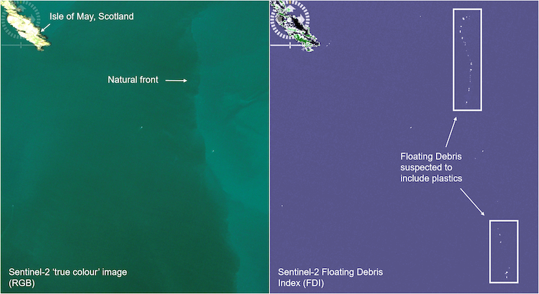
As ground-based monitoring of water quality requires considerable capacity, advancements in space technologies, such as more precise polarimetric sensors, would all (Oluwafemi and Olubiyi 2019). Several projects are exploring the use of remote sensing to monitor plastics within Earth’s surface waters (Figure 6). By using Sentinel-2 satellites and building an algorithm to develop a “floating debris index” (FDI), researchers are beginning to identify microplastics in the ocean. The high spatial resolution of up to 10 m from these satellites offers enormous potential (Biermann et al. 2020).
Finally, spin-off technologies have further potential to actively contribute to SDG 6. For example, advancements in urine purification developed for astronauts are able to provide clean drinking water and wastewater treatment, addressing Targets 6.1 and 6.3. Aquaporins, proteins that can transport water through cell membranes, whilst rejecting other substance, using forward-osmosis, can remove over 95% of micropollutants. Currently, a number of pilot projects are testing aquaporins in different applications, delivering exciting results for providing clean, potable water which could one day ease water stress in critical regions (NASA 2021).
Whilst we evidently have a long way to go to realise the SDG 6 targets, untapped potential of space technologies used effectively alongside more traditional methods offers hope. Whether clean water, safe sanitation and hygiene are realised everywhere by 2030 is dependent on the actions of the coming years. The questions remain: can sufficient progress be made, can this progress by accurately monitored, and what role will space technologies play in the unfolding story?
Biermann, Lauren, Daniel Clewley, Victor Martinez-vicente, and Konstantinos Topouzelis. 2020. “Finding Plastic Patches in Coastal Waters Using Optical Satellite Data.” Scientific Reports, 1–10. https://doi.org/10.1038/s41598-020-62298-z.
Charou, E, Papadopoulou Th D, M Stefouli, S Gyftakis, N Stathopoulos, and E Vasileiou. 2013. “Remote Sensing of Soil Moisture and Wetland Dynamics Using SMOS Data . Application in the Mediterranean Basin.” Remote Sensing.
Chuvieco, Emilio. 2016. Fundamentals of Satellite Remote Sensing. 2nd ed. CRC Press.
Entekhabi, D. 2010. “The Soil Moisture Active Passive (SMAP) Mission.” Proceedings of IEEE 98 (5): 704–16.
Giurgiu, R, R Suters, C Lasseur, P Scheer, and D Vodnar. 2017. “From Waste to Taste ; Closing the MELiSSA Loops for Escaping and Sustaining the Earth Habitat (Poster Flash Talk).” In 51st ESLAB SYMPOSIUM, 114–15.
Guzinski, Radoslaw, Steve Kass, Silvia Huber, Peter Bauer-gottwein, Iris Hedegaard Jensen, Vahid Naeimi, Marcela Doubkova, Andreas Walli, and Christian Tottrup. 2014. “Enabling the Use of Earth Observation Data for Integrated Water Resource Management in Africa with the Water
Observation and Information System.” Remote Sensing. https://doi.org/10.3390/rs6087819.
Hadjimitsis, Diofantos Glafkou, Marinos Glafkou Hadjimitsis, Leonidas Toulios, and Chris Clayton. 2010. “Use of Space Technology for Assisting Water Quality Assessment and Monitoring of Inland Water Bodies.” Physics and Chemistry of the Earth, Parts A/B/C 35 (1–2): 115–20. https://doi.org/10.1016/j.pce.2010.03.033.
Hannay, Guy. 2020. “Using Satellite Imagery to Report Changes to Water Bodies for SDG 6.6.1.” Data Science Campus, 2020.
Hulme, David. 2009. The Millennium Development Goals (MDGs): A Short History of the World’s Biggest Promise.
Leadership Council of the Sustainable Development Solutions Network [LCSDGN]. 2015. “Indicators and a Monitoring Framework for the Sustainable Development Goals: Launching a Data Revolution for the SDGs.”
NASA. 2014. “SMAP Soil Moisture Active Passive.”
NASA. 2019. “NASA Spin Off 2019.”
NASA. 2021. “NASA Spin Off 2021.”
National Research Council, Division on Engineering and Physical Sciences, Space Studies Board, and Committee on Earth Science And Applications from Space. 2007. “Part II: Mission Summaries.” In EARTH SCIENCE AND APPLICATIONS FROM SPACE. Washington: The National Academies Press.
Oluwafemi, F A, and R A Olubiyi. 2019. “Space Technology Applications for Water Quality in Sustainable Development.” Space Science and Technology for Sustainable Development AZOJETE 15: 100–109.
Pedersen, Claus Stig. 2018. “The UN Sustainable Development Goals (SDGs) Are a Great Gift to Business!” In 25th CIRP Life Cycle Engineering (LCE) Conference, 21–24. Denmark: The Author(s). https://doi.org/10.1016/j.procir.2018.01.003.
Ritchie, Jerry C, Paul V Zimba, and James H Everitt. 2003. “Remote Sensing Techniques to Assess Water Quality.” American Society for Photogrammetric & Remote Sensing 69 (6): 695–704.
Sheffield, J., E. F. Wood, M. Pan, H. Beck, G. Coccia, A. Serrat-Capdevila, and K. Verbist. 2018. “Satellite Remote Sensing for Water Resources Management: Potential for Supporting Sustainable Development in Data-Poor Regions.” Water Resources Research 54 (12): 9724–58. https://doi.org/10.1029/2017WR022437.
Sun, Alexander Y. 2013. “Predicting Groundwater Level Changes Using GRACE Data.” Water Resources Research 49 (9): 5900–5912. https://doi.org/10.1002/wrcr.20421.
UN-Water. 2020. “The Sustainable Development Goal 6 Global Acceleration Framework.”
Unicef and World Health Organisation. 2015. “Progress on Sanitation and Drinking Water – 2015 Update and MDG Assessment.”
UNICEF, and WHO. 2020. “State of the World’s Sanitation: An Urgent Call to Transform Sanitation for Better Health, Environments, Economies and Societies. Summary Report.” New York.
United Nations. 2020. “The Sustainable Development Goals Report 2020.”
United Nations Statistics Division. 2021. “SDG Indicators Metadata Repository.” Sustainable Development Goals. 2021.
UNOOSA. 2018. “European Global Navigation Satellite System and Copernicus: Supporting the Sustainable Development Goals.”
Water Aid. 2019. “Beneath the Surface: The State of the World’s Water 2019.”
World Health Organization. 2017. “Methodological Note: Indicators and Proposed Monitoring Framework for Means of Implementation (MoI) Targets for Sustainable Development Goal 6 (Draft).” Geneva.
World Health Organisation. 2019. National Systems to Support Drinking-Water, Sanitation and Hygiene: Global Status Report 2019.